
Santa Fe topographic map
Interactive map
Click on the map to display elevation.
About this map
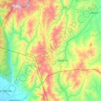
Name: Santa Fe topographic map, elevation, terrain.
Location: Santa Fe, Nueva Vizcaya, Cagayan Valley, 3705, Philippines (16.11889 120.76897 16.25597 121.07495)
Average elevation: 820 m
Minimum elevation: 63 m
Maximum elevation: 2,137 m
Other topographic maps
Click on a map to view its topography, its elevation and its terrain.
Mount Pulag
Philippines > Nueva Vizcaya > Kayapa
At lower elevations, Mount Pulag has a mossy forest full of ferns, lichens, and moss.
Average elevation: 2,572 m
Mount Pulag
Philippines > Nueva Vizcaya > Kayapa
At lower elevations, Mount Pulag has a mossy forest full of ferns, lichens, and moss.
Average elevation: 2,572 m