
Make a donation
Addis Ababa topographic map
Click on the map to display elevation.
Make a donation
Addis Ababa
Moreover, the city held strong social organization patterns prior to the Italian invasion. According to Richard Pankhurst (1968), the city's accelerated population growth was due to factors of provisional governors and their troops, the 1892 famine, and eventually the Battle of Adwa. Another includes the 1907 land act, municipal administration in 1909, and a railway and modernized transportation system boom beginning in the 20th century, culminating in continual growth. Additional supplements, for example the laying of Ethio-Djibouti Railways and topographical factors further led the city's boundary to expand southward.
Make a donation
About this map
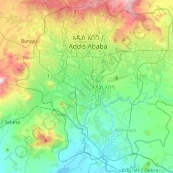
Name: Addis Ababa topographic map, elevation, terrain.
Location: Addis Ababa, Ethiopia (8.83311 38.63990 9.09858 38.90805)
Average elevation: 2,371 m
Minimum elevation: 2,044 m
Maximum elevation: 3,195 m
Make a donation
Other topographic maps
Click on a map to view its topography, its elevation and its terrain.
Addis Ababa
Ethiopia > Addis Ababa > Arada
Moreover, the city held strong social organization patterns prior to the Italian invasion. According to Richard Pankhurst (1968), the city's accelerated population growth was due to factors of provisional governors and their troops, the 1892 famine, and eventually the Battle of Adwa. Another includes the 1907…
Average elevation: 2,517 m
Make a donation
Ankober
Ankober (Amharic: አንኮበር), formerly known as Ankobar, is a town in central Ethiopia. Located in the North Shewa Zone of the Amhara Region, it's perched on the eastern escarpment of the Ethiopian Highlands at an elevation of about 2,465 meters (8,100 ft). It is 40 kilometers (25 mi) to the east of…
Average elevation: 2,672 m
Fiche
Fiche is a town in central Ethiopia. It is the administrative centre of the Kaba Shewa Zone of Oromia and separate District. It is located about three km from the main Addis Ababa-Debre Marqos road, Fiche has a latitude and longitude of 9°48′N 38°44′E / 9.800°N 38.733°E / 9.800; 38.733 and an…
Average elevation: 2,760 m
Make a donation