
Thank you for supporting this site ❤️
Make a donation
Make a donation
Ubon Ratchathani Province topographic map
Click on the map to display elevation.
Thank you for supporting this site ❤️
Make a donation
Make a donation
About this map
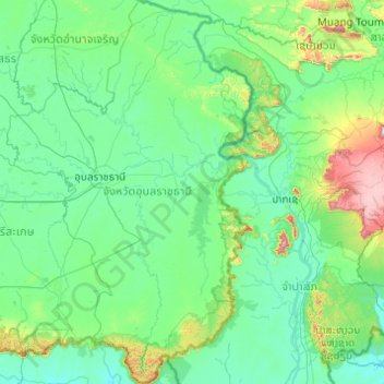
Name: Ubon Ratchathani Province topographic map, elevation, terrain.
Location: Ubon Ratchathani Province, Thailand (14.20957 104.38147 16.09787 105.63681)
Average elevation: 206 m
Minimum elevation: 69 m
Maximum elevation: 1,564 m
Thank you for supporting this site ❤️
Make a donation
Make a donation
Other topographic maps
Click on a map to view its topography, its elevation and its terrain.
Thank you for supporting this site ❤️
Make a donation
Make a donation
Bang Phriang Subdistrict Administrative Organization
Thailand > Samut Prakan Province
Average elevation: 20 m
Thank you for supporting this site ❤️
Make a donation
Make a donation
Thank you for supporting this site ❤️
Make a donation
Make a donation
Thank you for supporting this site ❤️
Make a donation
Make a donation
Bangkok
Bangkok is situated in the Chao Phraya River delta in Thailand's central plain. The river meanders through the city in a southerly direction, emptying into the Gulf of Thailand approximately 25 kilometres (16 mi) south of city centre. The area is flat and low-lying, with an average elevation of 1.5 metres (4…
Average elevation: 4 m