
Thank you for supporting this site ❤️
Make a donation
Make a donation
Ban Khun Se topographic map
Click on the map to display elevation.
Thank you for supporting this site ❤️
Make a donation
Make a donation
About this map
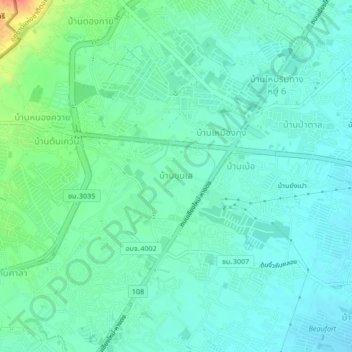
Name: Ban Khun Se topographic map, elevation, terrain.
Location: Ban Khun Se, San Phak Wan, Saraphi District, 50230, Thailand (18.69974 98.91895 18.73974 98.95895)
Average elevation: 315 m
Minimum elevation: 302 m
Maximum elevation: 355 m
Thank you for supporting this site ❤️
Make a donation
Make a donation
Other topographic maps
Click on a map to view its topography, its elevation and its terrain.
Bang Bua Thong Town Municipality
Thailand > Nonthaburi Province > Bang Bua Thong District
Average elevation: 4 m
Thank you for supporting this site ❤️
Make a donation
Make a donation
Ubon Ratchathani City Municipality
The elevation is 410 ft (125 m). It is 615 km (382 mi) from Bangkok.
Average elevation: 121 m
Thank you for supporting this site ❤️
Make a donation
Make a donation
Thank you for supporting this site ❤️
Make a donation
Make a donation
Ban Luang Subdistrict Administrative Organization
Thailand > Phra Nakhon Si Ayutthaya Province
Average elevation: 5 m
Maha Phram Subdistrict Municipality
Thailand > Phra Nakhon Si Ayutthaya Province > Bang Ban District
Average elevation: 5 m
Thank you for supporting this site ❤️
Make a donation
Make a donation