
Make a donation
Camden County topographic map
Click on the map to display elevation.
Make a donation
About this map
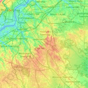
Name: Camden County topographic map, elevation, terrain.
Location: Camden County, New Jersey, United States (39.60829 -75.13954 39.99608 -74.73631)
Average elevation: 26 m
Minimum elevation: -3 m
Maximum elevation: 79 m
Make a donation
Other topographic maps
Click on a map to view its topography, its elevation and its terrain.
Basking Ridge
United States > New Jersey > Somerset County > Bernards Township
Average elevation: 98 m
Croxton
United States > New Jersey > Hudson County > Jersey City > Journal Square
Average elevation: 16 m
Make a donation
Charleston East
United States > New Jersey > Camden County > Cherry Hill Township
Average elevation: 23 m
Make a donation
Homes Mills
United States > New Jersey > Monmouth County > Upper Freehold Township
Average elevation: 34 m
Possumtown
United States > New Jersey > Middlesex County > Piscataway Township
Average elevation: 19 m
Robinsville
United States > New Jersey > Monmouth County > Upper Freehold Township
Average elevation: 56 m
Lawrence Brook Manor
United States > New Jersey > Middlesex County > East Brunswick Township
Average elevation: 19 m
Make a donation
Randolphville
United States > New Jersey > Middlesex County > Piscataway Township
Average elevation: 26 m
Paulas Corners
United States > New Jersey > Middlesex County > East Brunswick Township
Average elevation: 29 m
East Trenton Heights
United States > New Jersey > Mercer County > Hamilton Township
Average elevation: 22 m
Make a donation
North Hudson Park
United States > New Jersey > Hudson County > North Bergen > Hudson Heights
Average elevation: 41 m
Make a donation
Make a donation
Centerville
United States > New Jersey > Hunterdon County > Readington Township
Average elevation: 49 m
North Stelton
United States > New Jersey > Middlesex County > Piscataway Township
Average elevation: 29 m
Make a donation
Washington Valley
United States > New Jersey > Morris County > Morris Township
Average elevation: 152 m
Make a donation
Make a donation
High Rock Mountain
United States > New Jersey > Warren County > White Township
Average elevation: 189 m
Make a donation
Make a donation
Lincoln
United States > New Jersey > Gloucester County > South Harrison Township
Average elevation: 37 m
Make a donation
Freneau Woods Park
United States > New Jersey > Monmouth County > Aberdeen Township > Henningers Mill
Average elevation: 23 m
Make a donation
High Point
United States > New Jersey > Sussex County > Montague Township
High Point is a mountain peak within High Point State Park on the border of Wantage Township and Montague Township, Sussex County, New Jersey. Located in the portion of the state known as the Skylands, it is the highest elevation in the state, with a peak elevation of 1,803 feet (550 m). The closest city is…
Average elevation: 415 m
Make a donation
Make a donation
Make a donation
Creesville
United States > New Jersey > Gloucester County > Washington Township
Average elevation: 32 m
Make a donation
Make a donation
Middlesex Downs
United States > New Jersey > Middlesex County > Monroe Township
Average elevation: 33 m
Make a donation
Burlington Heights
United States > New Jersey > Monmouth County > Freehold Township
Average elevation: 47 m
Make a donation
Hendrickson Corners
United States > New Jersey > Monmouth County > Middletown Township
Average elevation: 22 m
Elmer B Boyd Park
United States > New Jersey > Middlesex County > New Brunswick > Feaster Park
Average elevation: 22 m
Make a donation
Make a donation
Powder Mill Pond Dam
United States > New Jersey > Morris County > Parsippany-Troy Hills > Tabor
Average elevation: 178 m
Remsterville
United States > New Jersey > Salem County > Alloway Township > Alloway Township
Average elevation: 15 m
Make a donation
Columbia Lakes
United States > New Jersey > Camden County > Cherry Hill Township
Average elevation: 17 m
Make a donation
Make a donation