
Thank you for supporting this site ❤️
Make a donation
Make a donation
Karrsville topographic map
Click on the map to display elevation.
Thank you for supporting this site ❤️
Make a donation
Make a donation
About this map
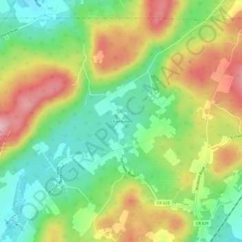
Name: Karrsville topographic map, elevation, terrain.
Average elevation: 226 m
Minimum elevation: 136 m
Maximum elevation: 346 m
Thank you for supporting this site ❤️
Make a donation
Make a donation
Other topographic maps
Click on a map to view its topography, its elevation and its terrain.
Anderson
United States > New Jersey > Warren County > Mansfield Township > Anderson
Average elevation: 153 m
Port Murray
United States > New Jersey > Warren County > Mansfield Township > Port Murray
Average elevation: 222 m