
Thank you for supporting this site ❤️
Make a donation
Make a donation
Bongsanglay Natural Park topographic map
Click on the map to display elevation.
Thank you for supporting this site ❤️
Make a donation
Make a donation
About this map
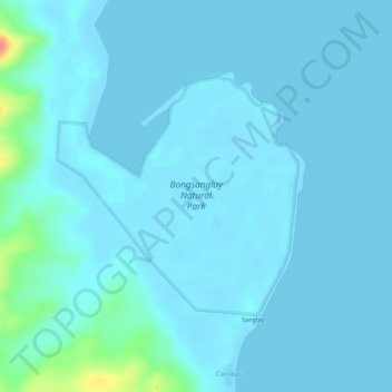
Name: Bongsanglay Natural Park topographic map, elevation, terrain.
Location: Bongsanglay Natural Park, Masbate, Bicol Region, Philippines (12.36027 123.78296 12.37674 123.80009)
Average elevation: 6 m
Minimum elevation: -1 m
Maximum elevation: 59 m
Thank you for supporting this site ❤️
Make a donation
Make a donation
Other topographic maps
Click on a map to view its topography, its elevation and its terrain.
Thank you for supporting this site ❤️
Make a donation
Make a donation
Thank you for supporting this site ❤️
Make a donation
Make a donation
Thank you for supporting this site ❤️
Make a donation
Make a donation
Cawayan
The locals of Cawayan still largely depend on subsistence farming despite its topographic advantage to adapt commercial farming. The lack of funding for agriculture and infrastructure and its political insecurity due to the presence and activities of armed groups kept by political families and other subversive…
Average elevation: 12 m
Thank you for supporting this site ❤️
Make a donation
Make a donation
Thank you for supporting this site ❤️
Make a donation
Make a donation
Thank you for supporting this site ❤️
Make a donation
Make a donation
Thank you for supporting this site ❤️
Make a donation
Make a donation
Thank you for supporting this site ❤️
Make a donation
Make a donation
Thank you for supporting this site ❤️
Make a donation
Make a donation
Thank you for supporting this site ❤️
Make a donation
Make a donation
Thank you for supporting this site ❤️
Make a donation
Make a donation
Thank you for supporting this site ❤️
Make a donation
Make a donation