
Thank you for supporting this site ❤️
Make a donation
Make a donation
Pio V. Corpus topographic map
Click on the map to display elevation.
Thank you for supporting this site ❤️
Make a donation
Make a donation
About this map
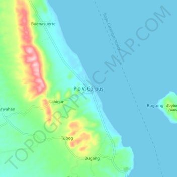
Name: Pio V. Corpus topographic map, elevation, terrain.
Location: Pio V. Corpus, Masbate, Bicol Region, Philippines (11.84372 124.00891 11.92372 124.08891)
Average elevation: 39 m
Minimum elevation: 0 m
Maximum elevation: 231 m
Thank you for supporting this site ❤️
Make a donation
Make a donation
Other topographic maps
Click on a map to view its topography, its elevation and its terrain.
Thank you for supporting this site ❤️
Make a donation
Make a donation
Jintotolo Island
Philippines > Masbate > Jintotolo
Its elevation was recorded at around 120 feet (37 m) in 1919. A lighthouse with a tower at 51 feet (16 m) in height exists on Jintotolo island.
Average elevation: 6 m
Thank you for supporting this site ❤️
Make a donation
Make a donation
Thank you for supporting this site ❤️
Make a donation
Make a donation