
Make a donation
Zamboanga Sibugay topographic map
Click on the map to display elevation.
Make a donation
About this map
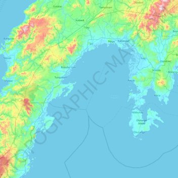
Name: Zamboanga Sibugay topographic map, elevation, terrain.
Location: Zamboanga Sibugay, Zamboanga Peninsula, Philippines (7.13275 122.22628 7.96014 123.11026)
Average elevation: 107 m
Minimum elevation: -3 m
Maximum elevation: 1,097 m
Make a donation
Other topographic maps
Click on a map to view its topography, its elevation and its terrain.
Quezon City
Founded as a pueblo by Saint Pedro Bautista in 1590, San Francisco del Monte may be considered Quezon City's oldest district. The original land area of the old town of San Francisco del Monte was approximately2.5 square kilometres (1.0 sq mi) and covered parts of what is currently known as Project 7 and 8 and…
Average elevation: 57 m
Legazpi
Legazpi's topography is generally plain on the northeastern areas, with slopes ranging from five to fifteen degrees. The southern areas have mostly rolling to hilly terrain. In the city's coastal areas, the terrain varies from plain (north) to hilly (south). Legazpi is criss-crossed by several rivers including…
Average elevation: 150 m
Zamboanga City
Philippines > Zamboanga Peninsula > Zamboanga City
The overall topography of the city could be described as rolling to very steep. There are some flat lands, mostly narrow strips along the east coast. The urban center is mostly flat with a gentle slope to the interior, ranging from 0 to 3%. The highest registered elevation is 1,200 metres. In terms of slope, a…
Average elevation: 83 m
Make a donation
Cabadbaran
Philippines > Agusan del Norte
It is 29 kilometres (18 mi) from Butuan. It is generally flat with rolling hills and swamplands in its western part. The highest of all mountains in the Caraga region, Mount Hilong-Hilong (with an altitude of 2,012 metres (6,601 ft) above sea level), rises in this city.
Average elevation: 179 m
Baguio
In 1903, Filipinos, Japanese and Chinese workers were hired to build Kennon Road, the first road directly connecting Baguio with the lowlands of La Union and Pangasinan. Before this, the only road to Benguet was Naguilian Road, and it was largely a horse trail at higher elevations. Camp John Hay was…
Average elevation: 881 m
Make a donation
Bacolod
Bacólod (English: Bacolod), is derived from bakólod (Old Spelling: bacólod), the Old Hiligaynon (Old Ilonggo) (Old Spelling: Ylongo and Ilongo) word for a "hill, turtle, mound, rise, hillock, down, any small eminence or elevation", since the resettlement was founded on a stony, hilly area, now the barangay…
Average elevation: 49 m
Make a donation
Malolos
Malolos is relatively flat of about 0.81% to a gently sloping of 2.17%. The slope of the land descends towards west, southwest to southern direction. The highest land elevation is at about 6.0 meters above sea level while the lowest is only half a meter below sea level. A network of natural waterways and…
Average elevation: 6 m
Make a donation
Make a donation
Make a donation
Mandaue
It is one of the two (the other one being the municipality of Consolacion) local government units located within the mainland Metro Cebu where the elevation of land is less than 100 m (330 ft).
Average elevation: 109 m
Make a donation
Janiuay
Santo Tomas approximate population is 500–800. Santo Tomas (Pakol to locals) is bounded by Madong in the east, Mangil in the north-east and Danao in the south west. It is accessible by three class C feeder roads in the east, south-west and south-east. Agriculture centers around rice, corn, coffee, beans,…
Average elevation: 82 m
Make a donation
Tagaytay
The southern and eastern portions of Tagaytay are covered by hills and mountains which is generally forests, pine trees and open grasslands. The city lies along Tagaytay Ridge, a ridge stretching about 32 kilometres (20 mi) from Mount Batulao in the west to Mount Sungay in the east with elevations averaging…
Average elevation: 229 m
San Juan
"San Juan" is a contraction of the city's traditional name of "San Juan del Monte" (lit. 'Saint John of the Mountain'). As with numerous other places in the Philippines, the name combines a patron saint and a toponym; in this case Saint John the Baptist with the locale's hilly terrain and relatively higher…
Average elevation: 35 m
Sorsogon City
Sorsogon City covers a land area of 31,292 hectares (120.82 sq mi). It is at the southernmost tip of the Bicol Peninsula and of Luzon Island. The city is bounded by Castilla in the west, Manito in the northwest, Albay Gulf in the north, Prieto Diaz in the east, Gubat in the southeast, Casiguran in the…
Average elevation: 89 m
Make a donation
Make a donation
Make a donation
Tublay
According to the Philippine Statistics Authority, the municipality has a land area of 102.55 square kilometres (39.59 sq mi) constituting 3.70% of the 2,769.08-square-kilometre- (1,069.15 sq mi) total area of Benguet. The topography is generally mountainous with an elevation of 1,400 metres (4,600 ft) above…
Average elevation: 1,256 m
Carcar
The land is generally level with less than 18% slope comprising 78.7% of the total land area. Areas with slopes ranging from 18 to 50% cover 19.3% of the total land area and those over 50% slope comprise approximately 1.9%. The highest recorded elevation is a little over 660 metres (2,170 ft) above sea level,…
Average elevation: 97 m
Make a donation
Santa Maria
The topography of Santa Maria is generally flat, however, it is becoming hilly towards the north. This area covers the barangays of Silangan, Mag-asawang Sapa, Pulong Buhangin and some parts of Balasing with landscape ranging from 8 to 18 percent slope. The rest of the barangays have a slope range from level…
Average elevation: 18 m
Trece Martires
The city of Trece Martires is characterised with ground elevation ranging from 30m to nearly 400m. Its ground slope ranges from 0.5 to 2%.
Average elevation: 150 m
Make a donation
Make a donation
Dumaguete
Philippines > Negros Oriental > Dumaguete
As a coastal city, it is bounded on the east by the Bohol Sea and the Tañon Strait, serving as a natural border of southeastern Negros Island Region to the neighboring Central Visayas. The city's topography is generally flat from two to six kilometers from the shoreline. It slopes gently upwards to the…
Average elevation: 167 m
Make a donation
San Gabriel
The Municipality of San Gabriel is recognized as the largest municipality by land area in La Union. The town’s topography is predominantly mountainous, gradually ascending eastward, with a mix of scrubland, grassland, and wetland ecosystems. Its landscape is traversed by the Baroro River, the town's major…
Average elevation: 131 m
Make a donation
Make a donation
Mount Halcon
Philippines > Oriental Mindoro
Mount Halcon (Filipino: Bundok Halcon) and (Spanish: Monte Halcón) is the highest mountain in Mindoro. According to the new data released by Oriental Mindoro peakvisor as of 2022, it has an elevation of 2,616 metres (8,583 ft) above sea level, higher than the previous estimates of 2,586 m (8,484 ft) although…
Average elevation: 2,121 m
Badoc
The celebrated Philippine painter Juan Luna was baptized in Badoc Church on 27 October 1857. At present, the church houses the miraculous statue of the Blessed Virgin Mary venerated under the title Virgin of Miracles, crowned by Catholic bishops in 1980, and was granted a Canonical coronation by Pope Francis…
Average elevation: 20 m
Make a donation
Make a donation
Make a donation
Make a donation
Make a donation
Make a donation
Make a donation
Make a donation