Geolocate

Southern Leyte topographic map

Interactive map

Click on the map to display elevation.

Southern Leyte

Along with other mountain forms in the province, Mount Nacolod in Hinunangan town has the highest peak with an elevation of 948 metres (3,110 ft) above sea level. Young volcanic rocks are discovered in the terrain areas, which cover the top of the southern mountain ranges of Mount Cabalian in the Pacific Area and Mount Nelangcapan in Panaon Area.

Wikipedia (CC-BY-SA 3.0)

About this map

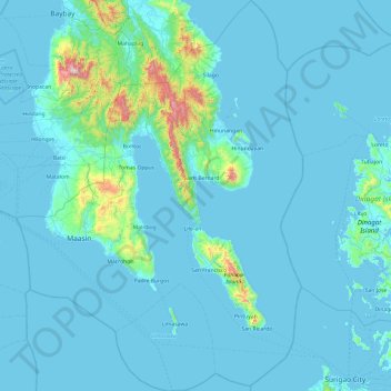
Name: Southern Leyte topographic map, elevation, terrain.

Location: Southern Leyte, Eastern Visayas, Philippines (9.76192 124.68340 10.70833 125.38922)

Average elevation: 66 m

Minimum elevation: -1 m

Maximum elevation: 1,113 m

Other topographic maps

Click on a map to view its topography, its elevation and its terrain.

Cebu City

Philippines > Cebu > Cebu City

Average elevation: 140 m

Quezon City

Philippines

Founded as a pueblo by Saint Pedro Bautista in 1590, San Francisco del Monte may be considered Quezon City's oldest district. The original land area of the old town of San Francisco del Monte was approximately2.5 square kilometres (1.0 sq mi) and covered parts of what is currently known as Project 7 and 8 and…

Average elevation: 57 m

San Fernando

Philippines > Pampanga

Average elevation: 24 m

Malabon

Philippines > Malabon > Malabon

Average elevation: 17 m

Malolos

Philippines > Bulacan

Malolos is relatively flat of about 0.81% to a gently sloping of 2.17%. The slope of the land descends towards west, southwest to southern direction. The highest land elevation is at about 6.0 meters above sea level while the lowest is only half a meter below sea level. A network of natural waterways and…

Average elevation: 6 m

Butuan

Philippines

Average elevation: 115 m

Bacolod

Philippines

Bacólod (English: Bacolod), is derived from bakólod (Old Spelling: bacólod), the Old Hiligaynon (Old Ilonggo) (Old Spelling: Ylongo and Ilongo) word for a "hill, turtle, mound, rise, hillock, down, any small eminence or elevation", since the resettlement was founded on a stony, hilly area, now the barangay…

Average elevation: 49 m

Dagupan

Philippines > Pangasinan

Average elevation: 12 m

Cabanatuan

Philippines > Nueva Ecija

Average elevation: 47 m

San Fernando

Philippines > La Union

Average elevation: 81 m

Mananga River

Philippines > Cebu City > Buot

Average elevation: 351 m

Pilar

Philippines > Samar > Calbayog

Average elevation: 92 m

Ampatuan

Philippines > Maguindanao del Sur

Average elevation: 49 m

Mandaluyong

Philippines

Another claims that the Spaniards named the place based on the report of a navigator named Acapulco, who saw the rolling hills frequently being lashed at by daluyong (“big waves from the sea”). This seems to confirm traditional pre-Hispanic stories that giant waves from the sea would meet the adjoining…

Average elevation: 33 m

San Juan

Philippines

"San Juan" is a contraction of the city's traditional name of "San Juan del Monte" (lit. 'Saint John of the Mountain'). As with numerous other places in the Philippines, the name combines a patron saint and a toponym; in this case Saint John the Baptist with the locale's hilly terrain and relatively higher…

Average elevation: 35 m

Lapu-Lapu

Philippines

Average elevation: 93 m

Montalban

Philippines > Rizal > Rodriguez

Rodriguez is generally very rough in topography, with 83% of its total land area composed of upland areas, hills and mountain ranges. The remaining 17% low-lying terrain and rolling lands are found at the south-western portion of the municipality, along with the northern portions of the Municipality of San…

Average elevation: 99 m

Caloocan

Philippines > Caloocan > Caloocan

Average elevation: 19 m

Tuy Baanan

Philippines > Laguna > Liliw

Average elevation: 196 m

Tatala

Philippines > Rizal > Binangonan

Average elevation: 52 m

Bulan

Philippines > Sorsogon

Average elevation: 5 m

Pulang Lupa

Philippines > Batangas > Mabini

Average elevation: 75 m

Sitio Bacao

Philippines > Nueva Ecija > Palayan

Average elevation: 152 m

Santa Ines

Philippines > Nueva Ecija > Cabiao

Average elevation: 12 m

Salvador

Philippines > Leyte > Tanauan

Average elevation: 12 m

Pambujan

Philippines > Northern Samar

Average elevation: 2 m

Kawit

Philippines > Zamboanga del Sur > Pagadian

Average elevation: 21 m

Oga

Philippines > Catanduanes > Pandan

Average elevation: 28 m

Calabgan

Philippines > Aurora > Casiguran

Average elevation: 39 m

Tinurik

Philippines > Batangas > Tanauan

Average elevation: 143 m

Pias

Philippines > Ilocos Sur

Average elevation: 60 m

Perez

Philippines > Cavite > Trece Martires

Average elevation: 128 m

Nagkaysa

Philippines > Pangasinan > San Nicolas

Average elevation: 81 m

Sabang

Philippines > Aurora > Baler

Average elevation: 14 m

Mount Guiwan

Philippines > Nueva Vizcaya

Mount Guiwan is a mountain in the Sierra Madre range in Alfonso Castañeda, Nueva Vizcaya, Philippines. It is probably the highest peak of Sierra Madre mountain range with a height of at least 1,915 metres (6,283 ft) above sea level according to NAMRIA topographic map and perhaps as high as 1,950 metres (6,400…

Average elevation: 1,462 m

Zamboanga City

Philippines > Zamboanga Peninsula > Zamboanga City

The overall topography of the city could be described as rolling to very steep. There are some flat lands, mostly narrow strips along the east coast. The urban center is mostly flat with a gentle slope to the interior, ranging from 0 to 3%. The highest registered elevation is 1,200 metres. In terms of slope, a…

Average elevation: 83 m

Antipolo

Philippines > Rizal

Its higher elevation than that of Metro Manila affords it a scenic view of the metropolis, especially at night. Its locally grown mangoes and cashews are popular among tourists, as well as suman – a local delicacy made out of glutinous rice. The Hinulugang Taktak National Park, which was once a popular…

Average elevation: 125 m

Sorsogon City

Philippines > Sorsogon

Sorsogon City covers a land area of 31,292 hectares (120.82 sq mi). It is at the southernmost tip of the Bicol Peninsula and of Luzon Island. The city is bounded by Castilla in the west, Manito in the northwest, Albay Gulf in the north, Prieto Diaz in the east, Gubat in the southeast, Casiguran in the…

Average elevation: 89 m

Pasay

Philippines

Average elevation: 14 m

Tagaytay

Philippines > Cavite

The southern and eastern portions of Tagaytay are covered by hills and mountains which is generally forests, pine trees and open grasslands. The city lies along Tagaytay Ridge, a ridge stretching about 32 kilometres (20 mi) from Mount Batulao in the west to Mount Sungay in the east with elevations averaging…

Average elevation: 229 m

Amadeo

Philippines > Cavite > Amadeo

Average elevation: 422 m

San Pablo

Philippines > Laguna > San Pablo

Average elevation: 220 m

Bacoor

Philippines > Cavite

Average elevation: 18 m

Manila Bay

Philippines > Cavite

Average elevation: 0 m

Sitio Durog

Philippines > Iloilo > Nahapay

Average elevation: 101 m

Catangraran

Philippines > Ilocos Norte > Solsona

Average elevation: 109 m

Rubber

Philippines > South Cotabato > Polomolok

Average elevation: 268 m

Maislap

Philippines > Rizal > Montalban

Average elevation: 82 m

Baltao Subdivision

Philippines > Parañaque

Average elevation: 9 m

Santol

Philippines > Batangas > Tanauan

Average elevation: 197 m

Tabunok

Philippines > Cebu

Average elevation: 48 m

Sampaloc

Philippines > Rizal > Tanay

Average elevation: 394 m

Lambusan

Philippines > Cebu > San Remigio

Average elevation: 20 m

New Katipunan

Philippines > Agusan del Sur > Bayugan

Average elevation: 466 m

Mount Busa

Philippines > Sarangani

Average elevation: 1,757 m

Algga

Philippines > Camiguin > Catarman

Average elevation: 39 m

Tugaya

Philippines > Bukidnon > Valencia

Average elevation: 717 m

Estacion

Philippines > Tarlac > Paniqui

Average elevation: 18 m

Lupang Hinirang

Philippines > Bataan > Orani > Mulawin

Average elevation: 10 m

Ciudad Real

Philippines > Bulacan > San Jose del Monte

Average elevation: 113 m

Abinganan

Philippines > Nueva Vizcaya

Average elevation: 351 m

San Antonio

Philippines > Quirino

Average elevation: 165 m

Meyto

Philippines > Bulacan > Calumpit

Average elevation: 3 m

Hindangon

Philippines > Misamis Oriental > Gingoog

Average elevation: 522 m

Guinobatan

Philippines > Albay

Average elevation: 158 m

Malabnig

Philippines > Albay

Average elevation: 204 m

Mambog

Philippines > Bataan > Hermosa

Average elevation: 13 m

Santicon

Philippines > Cebu

Average elevation: 658 m

Dulong Tangke Creek

Philippines > Valenzuela

Average elevation: 8 m

Sapang Uwak

Philippines > Pampanga > Porac

Average elevation: 251 m

Danglas

Philippines > Abra

Average elevation: 166 m

Santa Ines

Philippines > Pampanga > Bacolor

Average elevation: 8 m

Balangiga

Philippines > Eastern Samar

Average elevation: 27 m

Cambuilao

Philippines > Negros Oriental > Bais

Average elevation: 9 m

Bago River

Philippines > Negros Occidental > Pulupandan > Ubay

Average elevation: 5 m

Deep Slope

Philippines > Cebu

Average elevation: 1 m

Bolo Creek

Philippines > Benguet > La Trinidad > Cruz > Central Buyagan

Average elevation: 1,321 m

Talisay

Philippines > Cebu

Average elevation: 100 m

Osorio

Philippines > Cavite > Trece Martires

Average elevation: 95 m

Luciente 1

Philippines > Pangasinan > Bolinao

Average elevation: 10 m

Cotcot

Philippines > Cebu

Average elevation: 12 m

Laguan

Philippines > Laguna > Liliw

Average elevation: 239 m

Calaocan

Philippines > Pangasinan > Manaoag

Average elevation: 24 m

Santo Niño

Philippines > Tacloban

Average elevation: 23 m

Fugu

Philippines > Cagayan

Average elevation: 33 m

Naruangan

Philippines > Cagayan > Tuao

Average elevation: 43 m

Bindoy

Philippines > Negros Oriental

Average elevation: 128 m

Mount Kalatungan

Philippines > Bukidnon > Pangantucan

Mount Kalatungan is the fifth highest mountain in the country with an elevation of 2,880 m (9,450 ft) asl. It is one of the several high elevation peaks in the Kalatungan Mountain Range in Bukidnon on the island of Mindanao, the second largest island in the Philippines.

Average elevation: 2,481 m

Mount Dulang-Dulang

Philippines > Bukidnon > Malaybalay

Mount Dulang-dulang, dubbed by Filipino mountaineers as "D2" and also known as Mount Katanglad, is the highest elevation peak in the Kitanglad Mountain Range, located in the north central portion of the province of Bukidnon in the island of Mindanao. It is the second highest mountain of the Philippines at…

Average elevation: 2,458 m

Isugan

Philippines > Negros Oriental > Bacong

Average elevation: 107 m

Atate

Philippines > Nueva Ecija > Palayan

Average elevation: 78 m

Aglipay

Philippines > Quirino

Average elevation: 141 m

Kidama

Philippines > North Cotabato > Matalam

Average elevation: 46 m

San Josef

Philippines > Nueva Ecija > Peñaranda

Average elevation: 41 m

Talayong

Philippines > Negros Oriental > La Libertad

Average elevation: 53 m

Montaña

Philippines > Batangas > Tanauan

Average elevation: 203 m

Upper Carmen

Philippines > Davao City

Average elevation: 97 m