
Thank you for supporting this site ❤️
Make a donation
Make a donation
Mount Silad topographic map
Click on the map to display elevation.
Thank you for supporting this site ❤️
Make a donation
Make a donation
About this map
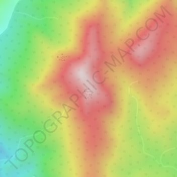
Name: Mount Silad topographic map, elevation, terrain.
Average elevation: 602 m
Minimum elevation: 255 m
Maximum elevation: 873 m
Thank you for supporting this site ❤️
Make a donation
Make a donation
Other topographic maps
Click on a map to view its topography, its elevation and its terrain.
Biak na Bato National Park
Philippines > Bulacan > Doña Remedios Trinidad > Biak na Bato
Average elevation: 127 m