Geolocate

Cagayan de Oro topographic map

Click on the map to display elevation.

Cagayan de Oro

Cagayan de Oro, located along the north-central coast of Mindanao, Philippines, encompasses a diverse topography that significantly influences its terrain. The city spans approximately 488.86 square kilometers (188.75 square miles), featuring a 25-kilometer (16 miles) coastline along Macajalar Bay. The landscape transitions from a narrow coastal plain to rolling hills and steeply inclined mountains as one moves inland. The Cagayan River, originating from the Kalatungan Mountain Range in Bukidnon, traverses the city before emptying into the bay, carving valleys and contributing to the area's varied elevation. This diverse terrain not only shapes the city's natural beauty but also impacts urban development and land use patterns.

About this map

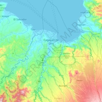
Name: Cagayan de Oro topographic map, elevation, terrain.

Location: Cagayan de Oro, Northern Mindanao, 9000, Philippines (8.25182 124.44721 8.62942 124.79667)

Average elevation: 224 m

Minimum elevation: -4 m

Maximum elevation: 1,000 m

Other topographic maps

Click on a map to view its topography, its elevation and its terrain.

Quezon City

Philippines

Founded as a pueblo by Saint Pedro Bautista in 1590, San Francisco del Monte may be considered Quezon City's oldest district. The original land area of the old town of San Francisco del Monte was approximately2.5 square kilometres (1.0 sq mi) and covered parts of what is currently known as Project 7 and 8 and…

Average elevation: 57 m

Rio Tuba

Philippines > Palawan

Average elevation: 10 m

Cabadbaran

Philippines > Agusan del Norte

It is 29 kilometres (18 mi) from Butuan. It is generally flat with rolling hills and swamplands in its western part. The highest of all mountains in the Caraga region, Mount Hilong-Hilong (with an altitude of 2,012 metres (6,601 ft) above sea level), rises in this city.

Average elevation: 179 m

Baao

Philippines > Camarines Sur > Baao

Average elevation: 48 m

Dagupan

Philippines > Pangasinan

Average elevation: 12 m

Baguio

Philippines

In 1903, Filipinos, Japanese and Chinese workers were hired to build Kennon Road, the first road directly connecting Baguio with the lowlands of La Union and Pangasinan. Before this, the only road to Benguet was Naguilian Road, and it was largely a horse trail at higher elevations. Camp John Hay was…

Average elevation: 881 m

Butuan

Philippines

Average elevation: 115 m

Bantay

Philippines > Ilocos Sur

It has an average elevation of 100 meters (328.08 feet), with a land area of 7,660 hectares (18,900 acres). It is an elevated and hilly municipality but some barangays, especially those near creeks, are prone to flooding during heavy typhoons.

Average elevation: 8 m

Tullahan River

Philippines > Quezon City

Average elevation: 39 m

Tagaytay

Philippines > Cavite

The southern and eastern portions of Tagaytay are covered by hills and mountains which is generally forests, pine trees and open grasslands. The city lies along Tagaytay Ridge, a ridge stretching about 32 kilometres (20 mi) from Mount Batulao in the west to Mount Sungay in the east with elevations averaging…

Average elevation: 229 m

Silang

Philippines > Cavite > Silang

Average elevation: 305 m

Jasaan

Philippines > Misamis Oriental

Average elevation: 77 m

Daraga

Philippines > Albay

67.3% of the total municipal land area has a predominantly low elevation of up to 100 metres (330 ft). The surface terrain is generally characterized by combination of level to nearly level areas, gentle to undulating areas and undulating to rolling areas.

Average elevation: 76 m

Lapu-Lapu

Philippines

Average elevation: 93 m

Cebu City

Philippines > Cebu > Cebu City

Average elevation: 140 m

Albay

Philippines

Average elevation: 48 m

Rizal

Philippines

Average elevation: 95 m

Tarlac

Philippines

Average elevation: 109 m

Lubuagan

Philippines > Kalinga

Average elevation: 809 m

Gloria

Philippines > Oriental Mindoro

Average elevation: 12 m

Salapungan

Philippines > Tarlac > Tarlac City

Average elevation: 42 m

Buhi

Philippines > Camarines Sur

Buhi has generally mountainous and hilly surface, with 50% of its area having a slope of around 25%. The Poblacion located on the south shore of Lake Buhi, has gently rolling topography.

Average elevation: 161 m

Asingan

Philippines > Pangasinan

Average elevation: 43 m

Tacurong

Philippines > Sultan Kudarat

Average elevation: 52 m

Alubijid

Philippines > Misamis Oriental

Average elevation: 50 m

Cuyapo

Philippines > Nueva Ecija

Average elevation: 34 m

Tuba

Philippines > Benguet

Tuba's topography is generally characterized by irregular rugged terrain and steep slopes with several mountain peaks rising from the table land itself. Mount Santo Tomas, the highest peak in the municipality soars to 2,252 metres (7,388 ft) above sea level.

Average elevation: 1,242 m

Echague

Philippines > Isabela

Average elevation: 71 m

Bacolod

Philippines

Bacólod (English: Bacolod), is derived from bakólod (Old Spelling: bacólod), the Old Hiligaynon (Old Ilonggo) (Old Spelling: Ylongo and Ilongo) word for a "hill, turtle, mound, rise, hillock, down, any small eminence or elevation", since the resettlement was founded on a stony, hilly area, now the barangay…

Average elevation: 49 m

Zamboanga City

Philippines > Zamboanga Peninsula > Zamboanga City

The overall topography of the city could be described as rolling to very steep. There are some flat lands, mostly narrow strips along the east coast. The urban center is mostly flat with a gentle slope to the interior, ranging from 0 to 3%. The highest registered elevation is 1,200 metres. In terms of slope, a…

Average elevation: 83 m

Upper Agno River Basin

Philippines > Benguet

Average elevation: 1,289 m

Bakakeng Norte

Philippines

Average elevation: 1,379 m

Cebu

Philippines

Average elevation: 89 m

Jabonga

Philippines > Agusan del Norte

The topography of the land features plain to rolling and hills. Among the municipalities, Jabonga ranks first in total area and number of farms (464) mostly owned by individuals. It has one of the 36 crop storage facilities of the province. Its major crops are coconut, rice, corn, timber and both fresh and…

Average elevation: 116 m

Mandaue

Philippines

It is one of the two (the other one being the municipality of Consolacion) local government units located within the mainland Metro Cebu where the elevation of land is less than 100 m (330 ft).

Average elevation: 109 m

Cadlan

Philippines > Camarines Sur > Pili

Average elevation: 40 m

Namabbalan Norte

Philippines > Cagayan > Tuguegarao

Average elevation: 42 m

Malainen Luma

Philippines > Cavite > Naic

Average elevation: 54 m

Pinabacdao

Philippines > Samar

For administrative and statistical convenience, barangays are group into two districts - the Pinabacdao East District and Pinabacdao West District. The East district is composed of barangays situated in high altitude areas or those located in the eastern part of the municipality. Barangays located along…

Average elevation: 11 m

Iba

Philippines > Zambales

Average elevation: 9 m

Cabangan

Philippines > Zambales

The municipality has a varied topography characterized by high mountains to narrow coastal plains. The most outstanding feature observable in the municipality is the Zambales Range.

Average elevation: 52 m

Palico

Philippines > Batangas > Tuy > Sabang

Average elevation: 51 m

Karilongan

Philippines > Davao City > Tawan-Tawan

Average elevation: 908 m

Old Cabalan

Philippines > Olongapo

Average elevation: 93 m

Davao City

Philippines

Average elevation: 65 m

Suplang

Philippines > Batangas > Tanauan > Suplang

Average elevation: 249 m

Zamboanga del Sur

Philippines

Average elevation: 118 m

Las Piñas

Philippines

Average elevation: 14 m

Gutalac

Philippines > Zamboanga del Norte

Average elevation: 133 m

Tayabas

Philippines > Quezon

Average elevation: 246 m

Caloocan

Philippines > Caloocan > Caloocan

Average elevation: 19 m

Montalban

Philippines > Rizal > Rodriguez

Rodriguez is generally very rough in topography, with 83% of its total land area composed of upland areas, hills and mountain ranges. The remaining 17% low-lying terrain and rolling lands are found at the south-western portion of the municipality, along with the northern portions of the Municipality of San…

Average elevation: 99 m

Marikina

Philippines

Average elevation: 80 m

Bakun

Philippines > Benguet

Average elevation: 1,458 m

Unisan

Philippines > Quezon

Average elevation: 15 m

Laoang

Philippines > Northern Samar

Average elevation: 5 m

Pinamalayan

Philippines > Oriental Mindoro

Average elevation: 17 m

Kiangan

Philippines > Ifugao

Average elevation: 828 m

Piñan

Philippines > Zamboanga del Norte

Average elevation: 60 m

Ampid 2

Philippines > Rizal

Average elevation: 30 m

Taguig

Philippines

Average elevation: 39 m

Bohol

Philippines

Average elevation: 116 m

Camarines Sur

Philippines

Average elevation: 56 m

Samar

Philippines

Average elevation: 38 m

Valenzuela

Philippines

The highest elevation point is 38 meters (125 ft) above sea level. Having a surface gradient of 0.55% and a gentle slope, hilly landscape is located in the industrial section of the city in Canumay. The average elevation point is 2 meters (6.6 ft) above sea level.

Average elevation: 24 m

San Felipe

Philippines > Zambales

Average elevation: 32 m

Mount Pulag

Philippines > Nueva Vizcaya

At lower elevations, Mount Pulag has a mossy forest full of ferns, lichens, and moss.

Average elevation: 2,572 m

Lucban

Philippines

Average elevation: 504 m

Tanay

Philippines > Rizal

Average elevation: 32 m

Iligan

Philippines

Average elevation: 229 m

Guiuan

Philippines > Eastern Samar

Average elevation: 6 m

Consolacion

Philippines > Cebu

Average elevation: 30 m

Lal-lo

Philippines > Cagayan

Average elevation: 18 m

Cabanatuan

Philippines > Nueva Ecija

Average elevation: 47 m

Pasay

Philippines

Average elevation: 14 m

Vigan

Philippines > Ilocos Sur

Vigan is situated in a Quaternary Age sedimentary plain called the Vigan-Bantay Plain which is part of the Ilocos coastal plain. The Vigan-Bantay Plain is bounded on the east by a moderately rugged Miocene sediments consisting of interbedded sandstones and shale to very rugged Meta-volcanics and Meta sediment…

Average elevation: 63 m

Malolos

Philippines > Bulacan

Malolos is relatively flat of about 0.81% to a gently sloping of 2.17%. The slope of the land descends towards west, southwest to southern direction. The highest land elevation is at about 6.0 meters above sea level while the lowest is only half a meter below sea level. A network of natural waterways and…

Average elevation: 6 m

Sabang

Philippines > Samar > Calbayog > Cagsalaosao

Average elevation: 11 m

Patag Island

Philippines

Average elevation: 0 m

Kota Island

Philippines

Average elevation: 0 m

Lankiam Cay

Philippines

Average elevation: 0 m

Sampaloc

Philippines > Rizal > Tanay

Average elevation: 394 m

San Remigio

Philippines > Cebu

Average elevation: 7 m

Davao Gulf

Philippines

Average elevation: 0 m

Lawak Island

Philippines

Average elevation: 0 m

Mount Ulap

Philippines > Benguet

Average elevation: 1,479 m

Compostela

Philippines > Cebu

Average elevation: 26 m

Laguindingan

Philippines > Misamis Oriental

Average elevation: 71 m

Abuyod

Philippines > Rizal > Teresa

Average elevation: 89 m

Tandag

Philippines > Surigao del Sur

Average elevation: 80 m

Ocampo

Philippines > Camarines Sur

Average elevation: 87 m

Surigao del Sur

Philippines

Average elevation: 274 m

Candaba

Philippines

Average elevation: 6 m

Kinatihan II

Philippines

Average elevation: 22 m

Ibabang Bukal

Philippines

Average elevation: 254 m

Cabatang

Philippines

Average elevation: 335 m

Pinget

Philippines

Average elevation: 1,430 m