
Make a donation
Cabuyao topographic map
Click on the map to display elevation.
Make a donation
About this map
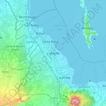
Name: Cabuyao topographic map, elevation, terrain.
Location: Cabuyao, Laguna, Calabarzon, 4025, Philippines (14.11955 120.96357 14.43955 121.28357)
Average elevation: 93 m
Minimum elevation: -4 m
Maximum elevation: 1,074 m
Make a donation
Other topographic maps
Click on a map to view its topography, its elevation and its terrain.
Laguna de Bay
Laguna de Bay (Spanish for "Lagoon/Lake of Bay"; Tagalog: Lawa ng Bay, [baɪ]), also known as Laguna Lake, is the largest lake in the Philippines. It is located southeast of Metro Manila, between the provinces of Laguna to the south and Rizal to the north. A freshwater lake, it has a surface area of 911–949…
Average elevation: 62 m
Make a donation
Majayjay
Majayjay is situated in the southernmost part of Laguna. It nestles at the foot of Mt. Banahaw, and due to its higher altitude at some 2,700+ ft above sea level, the town makes for a popular vacation destination during summer in the Philippines. It was once branded as the 'Summer Capital of the Philippines'…
Average elevation: 488 m
Make a donation
Make a donation
Make a donation
Make a donation
Kalayaan
Kalayaan is roughly rectangular in shape, with a hilly terrain on most of its eastern side, while relatively flat on its western side. Its highest elevations are from 400 to 418 metres. These are found in Sitio Santo Angel, Malaking Pulo, and Cabuhayan in Barangay San Juan, and Sitio Lamao in Barangay San…
Average elevation: 159 m
Luisiana
Locals call the town Little Amigos Dísmo because of its high elevation and cool climate like the City of Baguio.
Average elevation: 300 m
Make a donation
Pangil
The municipality is strategically situated at the southern tip of Sierra Madre mountain range (six barangays) and along the eastern margin of Jalajala Peninsula and just west of the northwestern shore of the easternmost major embayment of Laguna de Bay (two barangays). Its narrow strip of territory traverses…
Average elevation: 165 m
Make a donation
Siniloan
Buruwisan falls is located in Siniloan Laguna which is around eighty kilometers east of Manila. To get there we had to cross the long winding roads of Teresa and Bugarin to Mabitac. By public transport Take UV express vans bound to Tanay market in Starmall-Shaw terminal (P70). Then in Tanay market, ride a…
Average elevation: 120 m
Make a donation
Make a donation
Mounts Banahaw–San Cristobal Protected Landscape
Philippines > Laguna > Nagcarlan
Average elevation: 707 m
Make a donation
Make a donation
Make a donation
Make a donation
Make a donation
Make a donation
Balanac River Irrigation Dam
Philippines > Laguna > Magdalena > Ilayang Atingay
Average elevation: 56 m
Make a donation
Make a donation
Make a donation
Make a donation
Make a donation
Make a donation
Make a donation
Make a donation
Make a donation
Make a donation