
Session Road Area topographic map
Interactive map
Click on the map to display elevation.
About this map
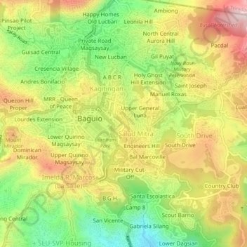
Name: Session Road Area topographic map, elevation, terrain.
Average elevation: 1,447 m
Minimum elevation: 1,256 m
Maximum elevation: 1,643 m
Other topographic maps
Click on a map to view its topography, its elevation and its terrain.
Manila
Almost all of Manila sits on top of centuries of prehistoric alluvial deposits built by the waters of the Pasig River and on some land reclaimed from Manila Bay. Manila's land has been altered substantially by human intervention, with considerable land reclamation along the waterfronts since the American…
Average elevation: 6 m
Metro Manila
The Coastal Margin or Lowland is a flat and low plain that faces Manila Bay. Located here is Manila, Navotas, parts of Malabon, and the western part and reclaimed areas of Pasay and Parañaque, where the ground elevation ranges from zero meters on Manila Bay to five meters at the west side of the cities of…
Average elevation: 43 m
Lipa
At the celebration of the elevation of Lipa to a city in January 1888, José Rizal was invited by Dr. Jose Lozada, Catalino Dimayuga and the brothers Celestino and Simeon Luz but Rizal responded only with his Hymno Al Trabajo which he dedicated to the zeal and industry of the Lipeños.
Average elevation: 208 m
Cagayan de Oro
Cagayan de Oro, located along the north-central coast of Mindanao, Philippines, encompasses a diverse topography that significantly influences its terrain. The city spans approximately 488.86 square kilometers (188.75 square miles), featuring a 25-kilometer (16 miles) coastline along Macajalar Bay. The…
Average elevation: 224 m
Laguna
Laguna is home to 24 mountains, most of which are inactive volcanoes. The highest peak in Laguna is Mt. Banahaw, with an elevation of 2,170 m (7,120 ft). Banahaw, unlike most other volcanoes in Laguna, is an active complex stratovolcano, which last erupted in 1843. Banahaw is located in the boundary of Laguna…
Average elevation: 183 m
Manila
Almost all of Manila sits on top of centuries of prehistoric alluvial deposits built by the waters of the Pasig River and on some land reclaimed from Manila Bay. Manila's land has been altered substantially by human intervention, with considerable land reclamation along the waterfronts since the American…
Average elevation: 12 m
Laguna de Bay
Laguna de Bay (Spanish for "Lagoon/Lake of Bay"; Tagalog: Lawa ng Bay, [baɪ]), also known as Laguna Lake, is the largest lake in the Philippines. It is located southeast of Metro Manila, between the provinces of Laguna to the south and Rizal to the north. A freshwater lake, it has a surface area of 911–949…
Average elevation: 62 m
Metro Manila
The Coastal Margin or Lowland is a flat and low plain that faces Manila Bay. Located here is Manila, Navotas, parts of Malabon, and the western part and reclaimed areas of Pasay and Parañaque, where the ground elevation ranges from zero meters on Manila Bay to five meters at the west side of the cities of…
Average elevation: 43 m
Batangas
Batangas is a combination of plains and mountains, including one of the world's smallest volcanoes, Mt. Taal, with an elevation of 600 metres (2,000 ft), located in the middle of the Taal Lake. Other important peaks are Mount Macolod with an elevation of 830 metres (2,720 ft), Mt. Banoy with 960 metres (3,150…
Average elevation: 126 m
Cavite
Another theory proposes that the name is a Hispanicized form of kabit, Tagalog for "joined", "connected", or "attached", referring to the peninsula's topographical relation to the mainland. Edmund Roberts, in his 1821 memoir, stated that the "natives" called it Caveit due to the "crooked point of land…
Average elevation: 88 m
Bataan
Bataan is divided by two mountain groups of volcanic origins. The northern side is composed of the Mount Natib (elevation 1,253 metres (4,111 ft)), Mount Sta. Rosa and Mount Silangan. The southern group is composed of Mount Mariveles, Mount Samat, and Mount Cuyapo. A narrow pass separates these two mountain…
Average elevation: 70 m
Quezon City
In order to make Quezon's dream a reality and to mobilize funds for the land purchase, the People's Homesite Corporation (PHC) was created on October 14, 1938, as a subsidiary of NDC, with an initial capital of ₱2 million. Roces was the chairman of the Board of PHC, and they immediately acquired the vast…
Average elevation: 39 m
Taytay
The shape of Taytay is rectangular – trapezoidal with gently hilly rolling terrain on its eastern side while relatively flat on its south-western side, including the poblacion. The municipality's highest elevation ranges from 200 to 255 meters which is situated along the inner north-eastern hills of Barangay…
Average elevation: 37 m
Cavite
Another theory proposes that the name is a Hispanicized form of kabit, Tagalog for "joined", "connected", or "attached", referring to the peninsula's topographical relation to the mainland. Edmund Roberts, in his 1821 memoir, stated that the "natives" called it Caveit due to the "crooked point of land…
Average elevation: 88 m
Muntinlupa
There are three plausible origins of the name of the city: First, is its association with the thin topsoil in the area; second, residents, purportedly replying to a question by Spaniards in the 16th century what the name of their place was, said “Monte sa Lupa”—apparently mistaking the question for what…
Average elevation: 21 m
Baguio
In 1903, Filipinos, Japanese and Chinese workers were hired to build Kennon Road, the first road directly connecting Baguio with the lowlands of La Union and Pangasinan. Before this, the only road to Benguet was Naguilian Road, and it was largely a horse trail at higher elevations. Camp John Hay was…
Average elevation: 1,371 m
Cagayan
The eastern coast forms the northern portion of the Sierra Madre mountain range, while the western limits are generally hilly to low in elevation. The central area, dominated by a large valley, forms the lower basin of the country's longest river, the Cagayan. The mouth is located at the northern town of…
Average elevation: 110 m
Marinduque
The highest peak in Marinduque is Mount Malindig (formerly called Mt. Marlanga), a potentially active stratovolcano with an elevation of 1,157 metres (3,796 ft) above sea level, located at the southern tip of the island.
Average elevation: 38 m
Valenzuela
The highest elevation point is 38 metres (125 ft) above sea level. Having a surface gradient of 0.55% and a gentle slope, hilly landscape is located in the industrial section of the city in Canumay. The average elevation point is 2 metres (6.6 ft) above sea level.
Average elevation: 6 m
Carigara
The climatic and topographical characteristics of Carigara's expansive terrain, encompassing wide rice fields and hilly landscapes, create an optimal environment for cultivating fruit-bearing trees, vegetables, and a variety of crops. Noteworthy trees suitable for cultivation include bananas, coconuts,…
Average elevation: 134 m
Isabela
The province is divided into three physiographic areas. The eastern area, straddled by the Sierra Madre mountain range, is rugged and thickly forested. A substantial portion is uncharted. These unexplored hinterlands are home to a rich variety of flora and fauna, and some are under government reservations. It…
Average elevation: 227 m
Aurora
The province covers a portion of the Sierra Madre mountain range. As such, the elevation is generally steep to very steep and only about 14% of the province's total area is flat.
Average elevation: 255 m
Bataan
Bataan is divided by two mountain groups of volcanic origins. The northern side is composed of the Mount Natib (elevation 1,253 meters (4,111 ft)), Mount Sta. Rosa and Mount Silangan. The southern group is composed of Mount Mariveles, Mount Samat, and Mount Cuyapo. A narrow pass separates these two mountain…
Average elevation: 70 m
Albay
The western coast of the province is mountainous but not as prominent as the eastern range with the highest elevation at around 490 metres (1,610 ft). Among these mountains are Mount Catburawan in Ligao and Mount Pantao in Oas.
Average elevation: 71 m
Sorsogon
The province has an irregular topography. Except for landlocked Irosin, all the towns lie along the coast. They are all connected by concrete and asphalt roads. Mountain's sprawl over the northeast, southeast and west portions. Mount Bulusan, the tallest peak, rises 1,560 metres (5,120 ft) above sea level.
Average elevation: 51 m
Masbate
The general surface configuration of the province ranges from slightly undulating to rolling and from hilly to mountainous. In each island, the rugged topography is concentrated in the northeastern portion and gradually recedes to blunt hills and rolling areas in the south, southeast, and southwest.
Average elevation: 28 m
Romblon
The province has a total land area of approximately 1,533.45 square kilometers (592 sq mi) representing about 5.3 percent of the total land area of Region IV-B Mimaropa. It is generally mountainous with about 40 percent of its land area having an inclination of more than 50 percent. Only four percent of the…
Average elevation: 16 m
Southern Leyte
Along with other mountain forms in the province, Mount Nacolod in Hinunangan town has the highest peak with an elevation of 948 metres (3,110 ft) above sea level. Young volcanic rocks are discovered in the terrain areas, which cover the top of the southern mountain ranges of Mount Cabalian in the Pacific Area…
Average elevation: 66 m
Dinagat Islands
Dinagat Islands is a young island-province at the northern tip of Mindanao. Many describe Dinagat Islands as a hidden gem of the Caraga Region XIII. The Islands are enriched with great bio-diversity, abundant natural wonders and rich resources. Dinagat Islands has a multitude of fascinating white sandy beaches…
Average elevation: 24 m
Aklan
Mount Nausang, is formerly the highest peak in Aklan, standing at 5,190 ft (1,580 m), the discovery of Mount Timbaban is much higher, with an elevation of 5,830.1 ft (1,777.0 m) above sea level, Mount Timbaban is not considered as independent mountain, it is still part of Mount Madja-as sub-summit with only…
Average elevation: 96 m
Antique
Mount Madja-as is located in Culasi, is the highest peak on the island of Panay. This 2,117-metre-high (6,946 ft) mountain is a dormant volcano with lakes and 14 waterfalls. It is said to be the legendary home of Bulalakaw, the supreme god of the ancients, and beckons as a challenge for hikers and trekkers.…
Average elevation: 53 m
Capiz
Capiz covers a total area of 2,594.64 square kilometres (1,001.80 sq mi) occupying the northeastern portion of Panay Island, and is one of the five provinces that compose the Western Visayas region. Mount Nangtud, is the highest mountain in Capiz with an elevation of 6,804 ft (2,074 m) located on the…
Average elevation: 123 m
Negros Occidental
Negros Occidental has a tropical climate due to the fact that it is situated close to the equator, being located at least nine degrees north of it. The northern section of the province has a tropical rainforest (Köppen: Af) climate, whereas the southern portion has a tropical monsoon (Köppen: Am) climate.…
Average elevation: 126 m
Cebu
Coal was first discovered in Cebu about 1837. There were 15 localities over the whole island, on both coasts; some desultory mining had been carried out Naga near Mount Uling, but most serious operations were at Licos and Camansi west of Compostela and Danao. Active work ceased about 1895 with the…
Average elevation: 91 m
Zamboanga del Norte
It has an average elevation of 243.8 metres (800 ft), with Mount Dabiak in Katipunan as the highest peak at 2,600 metres (8,500 ft). Other parts, near the coastlines, are plains. The province's irregular coastline runs some 400 kilometres (250 mi) from north to south.
Average elevation: 78 m
Davao Occidental
The topography of Davao Occidental is hilly, rugged and sloping, with nearly the whole province consisting of mountains. Its eastern shoreline consists of cliffs and beaches with hills immediately on their backs. Coconut trees and hardwood trees mostly dominate the provincial mainland.
Average elevation: 143 m
South Cotabato
Maximum daytime temperature throughout the province is in the range of 36 to 38 °C (97 to 100 °F), falling to 23 to 32 °C (73 to 90 °F) during the night depending on the elevation. The hottest period is January to April while July to December being the coolest.
Average elevation: 419 m