
Make a donation
Colchester topographic map
Click on the map to display elevation.
Make a donation
About this map
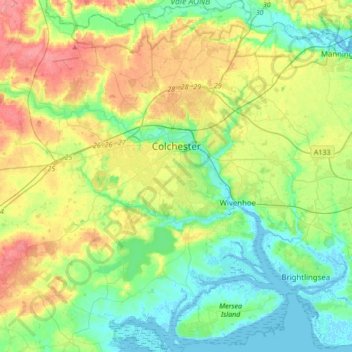
Name: Colchester topographic map, elevation, terrain.
Location: Colchester, Essex, England, United Kingdom (51.76571 0.69938 51.97715 1.02680)
Average elevation: 28 m
Minimum elevation: -3 m
Maximum elevation: 80 m
Make a donation
Other topographic maps
Click on a map to view its topography, its elevation and its terrain.
Canvey Island
United Kingdom > England > Essex > Castle Point > Canvey Island
In 1607 the Elizabethan antiquarian William Camden noted in his work Britannia (a topographical and historical survey of all of Great Britain and Ireland) that Canvey Island (which he called Island Convennon) was documented in the 2nd century by the Alexandrian geographer Ptolemy. In his work Geographia,…
Average elevation: 10 m
Make a donation
Wallasea Island
United Kingdom > England > Essex > Rochford > Paglesham Church End
Average elevation: 1 m
Make a donation
Make a donation
Make a donation
Make a donation
Make a donation
Make a donation
Make a donation
Make a donation
Roughtalley's Wood (South) & Epping Forest Woodland Burial Ground
United Kingdom > England > Essex > Epping Forest > Coopersale
Average elevation: 96 m
Make a donation
Make a donation
Nazeing Gate
United Kingdom > England > Essex > Epping Forest > Bumble's Green > Nazeing
Average elevation: 70 m
Make a donation
Make a donation
Make a donation
Make a donation
Make a donation
Coles Green
United Kingdom > England > Essex > Uttlesford > Berden > Little London
Average elevation: 100 m
Make a donation
Passingford Bridge
United Kingdom > England > Essex > Epping Forest > Stapleford Tawney
Average elevation: 53 m
Make a donation
Make a donation
Make a donation
Make a donation
Make a donation
Make a donation
Make a donation
M25 Pollution Control Device
United Kingdom > England > Essex > South Ockendon
Average elevation: 19 m
Make a donation