
Thank you for supporting this site ❤️
Make a donation
Make a donation
Kathmandu topographic map
Click on the map to display elevation.
Thank you for supporting this site ❤️
Make a donation
Make a donation
Kathmandu
Kathmandu, officially the Kathmandu Metropolitan City, is the seat of federal government and the most populous city in Nepal. As of the 2021 Nepal census, there were 845,767 inhabitants living in 105,649 households and approximately 4 million people in its surrounding agglomeration. It is located in the Kathmandu Valley, a large valley surrounded by hills in central Nepal, at an altitude of 4,344 feet (1,324 metres) above sea level.
Thank you for supporting this site ❤️
Make a donation
Make a donation
About this map
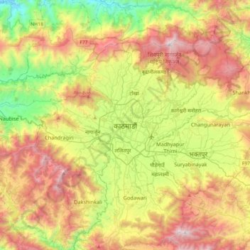
Name: Kathmandu topographic map, elevation, terrain.
Average elevation: 1,538 m
Minimum elevation: 606 m
Maximum elevation: 2,733 m
Thank you for supporting this site ❤️
Make a donation
Make a donation