
Mabini topographic map
Click on the map to display elevation.
About this map
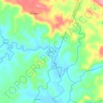
Name: Mabini topographic map, elevation, terrain.
Location: Mabini, Basey, Samar, Eastern Visayas, Philippines (11.35298 125.13023 11.39298 125.17023)
Average elevation: 47 m
Minimum elevation: 5 m
Maximum elevation: 133 m
Other topographic maps
Click on a map to view its topography, its elevation and its terrain.
Calbayog
Forty percent of the city's land area are plain and hilly terrains with elevation ranging from 5 to 20 metres (16 to 66 ft) above sea level. The rest are rugged mountain ranges with elevations from 300 to 700 metres (980 to 2,300 ft) above sea level. Flooding is minimized because of many rivers, brooks,…
Average elevation: 78 m
Silanga District of Catbalogan City
Philippines > Samar > Silanga District of Catbalogan City
Average elevation: 21 m
Calbayog
Forty percent of the city's land area are plain and hilly terrains with elevation ranging from 5 to 20 metres (16 to 66 ft) above sea level. The rest are rugged mountain ranges with elevations from 300 to 700 metres (980 to 2,300 ft) above sea level. Flooding is minimized because of many rivers, brooks,…
Average elevation: 78 m