
Make a donation
Tuscany topographic map
Click on the map to display elevation.
Make a donation
About this map
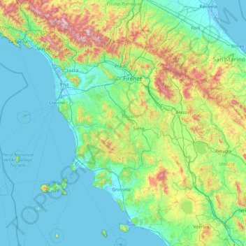
Name: Tuscany topographic map, elevation, terrain.
Location: Tuscany, Italy (42.23762 9.68677 44.47254 12.37227)
Average elevation: 267 m
Minimum elevation: -5 m
Maximum elevation: 2,029 m
Make a donation
Other topographic maps
Click on a map to view its topography, its elevation and its terrain.
Rome
Italy > Lazio > Roma Capitale
Although the city centre is about 24 km (15 mi) inland from the Tyrrhenian Sea, the city territory extends to the shore, where the south-western district of Ostia is located. The altitude of the central part of Rome ranges from 13 m (43 ft) above sea level (at the base of the Pantheon) to 139 m (456 ft) above…
Average elevation: 78 m
Matterhorn
Italy > Aosta Valley > Valtournenche
In 1999, the summit height was precisely determined to be at 4,477.54 m (14,690 ft) above sea level by using Global Positioning System technology as part of the TOWER Project (Top of the World Elevations Remeasurement) and to an accuracy of less than one centimetre, which allows future changes to be tracked.
Average elevation: 3,295 m
Gran Paradiso
Italy > Aosta Valley > Valsavarenche
The peak is the 7th highest mountain in the Graian Alps, with an elevation of 4,061 m. In the SOIUSA (International Standardized Mountain Subdivision of the Alps) the mountain belongs to an alpine subsection called "North-Eastern Graian Alps" (It:Alpi del Gran Paradiso; Fr:Alpes du Grand-Paradis) and also…
Average elevation: 3,459 m
Make a donation
Mount Vesuvius
Italy > Campania > Naples > Trecase
The volcano's slopes are scarred by lava flows, while the rest are heavily vegetated, with scrub and forests at higher altitudes and vineyards lower down.
Average elevation: 862 m
Mount Etna
During the first 1500 years AD, many eruptions went unrecorded (or records have been lost); among the more significant are: (1) an eruption in about 1030 AD near Monte Ilice on the lower southeast flank, which produced a lava flow that travelled about 10 km, reaching the sea north of Acireale; the villages of…
Average elevation: 1,157 m
Make a donation
Make a donation
Albana / Ibána / Albane
Italy > Friuli – Venezia Giulia > Udine / Udin / Videm > Prepotto / Prapotno / Prepot
Average elevation: 175 m
Make a donation
Make a donation
Matterhorn
Italy > Aosta Valley > Valtournenche
In 1999, the summit height was precisely determined to be at 4,477.54 m (14,690 ft) above sea level by using Global Positioning System technology as part of the TOWER Project (Top of the World Elevations Remeasurement) and to an accuracy of less than one centimetre, which allows future changes to be tracked.
Average elevation: 3,295 m
Make a donation
Gherdëina - Grödnertal - Val Gardena
Italy > Trentino – Alto Adige/Südtirol > South Tyrol > Urtijëi - St. Ulrich in Gröden - Ortisei
Average elevation: 1,607 m
Scale / Skale
Italy > Friuli – Venezia Giulia > Udine / Udin / Videm > Drenchia
Average elevation: 610 m
Make a donation
Make a donation
Casalalta
Italy > Umbria > Perugia > Collazzone
Casalalta is a frazione of the comune of Collazzone in the Province of Perugia, Umbria, central Italy. It stands at an elevation of 325 metres above sea level. At the time of the Istat census of 2001 it had 60 inhabitants.
Average elevation: 273 m
Make a donation
Monte Pastello
Italy > Veneto > Verona > Fumane
Monte Pastello is a mountain of the Veneto, Italy. The mountain, which has an elevation of 1,128 metres, is part of the Monti Lessini in the Venetian Prealps. It is located in the Province of Verona.
Average elevation: 698 m
Make a donation
Secëda - Monte Seceda
Italy > Trentino – Alto Adige/Südtirol > South Tyrol > Santa Cristina Gherdëina - St. Christina in Gröden - Santa Cristina Valgardena
Monte Seceda is a 2,519-meter-elevation (8,264-foot) summit in the Odles Group of the Dolomites, a UNESCO World Heritage Site. Set in the Trentino-Alto Adige/Südtirol region, the peak is located four kilometers (2.5 miles) north of the village of Santa Cristina Gherdëina, and the peak is in Puez-Geisler…
Average elevation: 2,106 m
Make a donation
Breuil-Cervinia
The ski area is very large and guarantees good snow quality during the season, being at a high altitude (2,050 m to 3,500 m).
Average elevation: 2,376 m
Erto / Nert
Italy > Friuli – Venezia Giulia > Pordenone / Pordenon > Erto e Casso
Average elevation: 1,112 m
Make a donation
Make a donation
Make a donation
Flading - Vallettina
Italy > Trentino – Alto Adige/Südtirol > South Tyrol > Ratschings - Racines
Average elevation: 2,012 m
Make a donation
Possessione Piccola
Italy > Emilia-Romagna > Bologna > San Giovanni in Persiceto
Average elevation: 25 m
Make a donation
Make a donation
Matterhorn
Italy > Aosta Valley > Valtournenche
In 1999, the summit height was precisely determined to be at 4,477.54 m (14,690 ft) above sea level by using Global Positioning System technology as part of the TOWER Project (Top of the World Elevations Remeasurement) and to an accuracy of less than one centimetre, which allows future changes to be tracked.
Average elevation: 3,295 m
Make a donation
Make a donation
Make a donation
Grünsee - Lago Verde
Italy > Trentino – Alto Adige/Südtirol > South Tyrol > Ulten - Ultimo
Average elevation: 2,683 m
Make a donation
Make a donation
Make a donation
Make a donation
Make a donation