
Make a donation
Mount Etna topographic map
Click on the map to display elevation.
Make a donation
Mount Etna
During the first 1500 years AD, many eruptions went unrecorded (or records have been lost); among the more significant are: (1) an eruption in about 1030 AD near Monte Ilice on the lower southeast flank, which produced a lava flow that travelled about 10 km, reaching the sea north of Acireale; the villages of Santa Tecla and Stazzo are built on the broad delta built by this lava flow into the sea; (2) an eruption in about 1160 (or 1224), from a fissure at only 350–450 m (1,148–1,476 ft) elevation on the south-southeast flank near the village of Mascalucia, whose lava flow reached the sea just to the north of Catania, in the area now occupied by the portion of the city named Ognina.
Make a donation
About this map
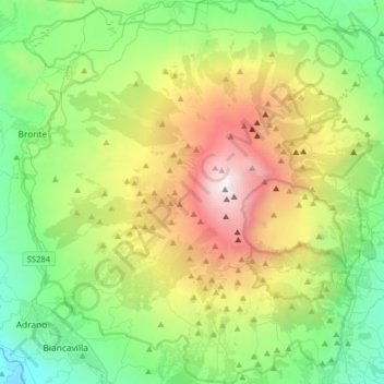
Name: Mount Etna topographic map, elevation, terrain.
Location: Mount Etna, Catania, Sicily, Italy (37.62235 14.82551 37.87524 15.13241)
Average elevation: 1,157 m
Minimum elevation: 144 m
Maximum elevation: 3,312 m
Make a donation
Other topographic maps
Click on a map to view its topography, its elevation and its terrain.
Mount Etna
During the first 1500 years CE, many eruptions went unrecorded (or records have been lost); among the more significant are: (1) an eruption in about 1030 CE near Monte Ilice on the lower southeast flank, which produced a lava flow that travelled about 10 km, reaching the sea north of Acireale; the villages of…
Average elevation: 1,157 m
Etna
Italy > Sicily > Catania > Zafferana Etnea
Eruptions of Etna follow multiple patterns. Most occur at the summit, where there are five distinct craters: the Northeast Crater, the Voragine, the Bocca Nuova, and two at the Southeast Crater Complex. Other eruptions occur on the flanks, which have more than 300 vents ranging in size from small holes in the…
Average elevation: 2,976 m
Make a donation
Randazzo
The geographical position of Randazzo also contributes to its climate. The town experiences a Mediterranean climate, characterized by hot, dry summers and mild, rainy winters. However, due to its proximity to Mount Etna, microclimates can be observed, with variations in temperature and precipitation depending…
Average elevation: 1,143 m
Make a donation
Motta Sant'Anastasia
The structure consists of three elevations. Only the first of these is still the original arched windows ogive (external) and at all sixth (inside). The other two square windows, on other levels, such as the current front door, go back to the 15th century.The ground floor was designed for military housing. In…
Average elevation: 104 m
Catania
Around 263 BC, the city was variously known as Catĭna (Latin: [ˈkatɪna]) and Catăna (Latin: [ˈkatana]; Ancient Greek: Κατάνη [katánɛː]). The former has been primarily used for its supposed assonance with catina, the Latin feminization of the name catinus. Catinus has two meanings: "a gulf, a…
Average elevation: 50 m
Make a donation
Make a donation
Maletto
The geographical location of Maletto also influences its climate. The town experiences a Mediterranean climate, characterized by hot, dry summers and mild, rainy winters. However, due to its proximity to Mount Etna, microclimates can be observed, with variations in temperature and precipitation depending on…
Average elevation: 983 m
Catania
Around 263 BC, the city was variously known as Catĭna (Latin: [ˈkatɪna]) and Catăna (Latin: [ˈkatana]; Ancient Greek: Κατάνη [katánɛː]). The former has been primarily used for its supposed assonance with catina, the Latin feminization of the name catinus. Catinus has two meanings: "a gulf, a…
Average elevation: 50 m
Make a donation
Make a donation
Catania
Around 263 BC, the city was variously known as Catĭna (Latin: [ˈkatɪna]) and Catăna (Latin: [ˈkatana]; Ancient Greek: Κατάνη [katánɛː]). The former has been primarily used for its supposed assonance with catina, the Latin feminization of the name catinus. Catinus has two meanings: "a gulf, a…
Average elevation: 50 m
Make a donation
Make a donation
Etna
Italy > Sicily > Catania > Zafferana Etnea
Eruptions of Etna follow multiple patterns. Most occur at the summit, where there are five distinct craters – the Northeast Crater, the Voragine, the Bocca Nuova, and two at the Southeast Crater Complex. Other eruptions occur on the flanks, which have more than 300 vents ranging in size from small holes in…
Average elevation: 2,976 m
Mount Etna
During the first 1500 years CE, many eruptions went unrecorded (or records have been lost); among the more significant are: (1) an eruption in about 1030 CE near Monte Ilice on the lower southeast flank, which produced a lava flow that travelled about 10 km, reaching the sea north of Acireale; the villages of…
Average elevation: 1,157 m
Make a donation
Etna
Italy > Sicily > Catania > Zafferana Etnea
Eruptions of Etna follow multiple patterns. Most occur at the summit, where there are five distinct craters – the Northeast Crater, the Voragine, the Bocca Nuova, and two at the Southeast Crater Complex. Other eruptions occur on the flanks, which have more than 300 vents ranging in size from small holes in…
Average elevation: 2,976 m
Make a donation