
Cochrane topographic map
Click on the map to display elevation.
Cochrane
Until 1977, Timmins was used as the source for all weather readings attributed to Cochrane except for exceptional extremes, due to the overall similar climate due to proximity and topography. However, in December 1977, Cochrane temperature readings began to be taken from downtown after a noticeable difference in temperature was recorded two years prior in January 1976. However, to this day, if Cochrane's weather equipment fails at any time, the Timmins temperature readings are used due to the overall similarity.
About this map
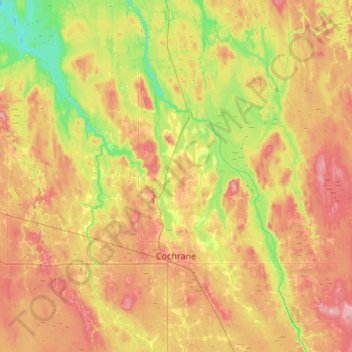
Name: Cochrane topographic map, elevation, terrain.
Average elevation: 262 m
Minimum elevation: 216 m
Maximum elevation: 311 m
Other topographic maps
Click on a map to view its topography, its elevation and its terrain.
Painkiller Lake
Canada > Ontario > Cochrane District > Black River-Matheson Township
Average elevation: 302 m
Borgford Lake
Canada > Ontario > Cochrane District > Black River-Matheson Township
Average elevation: 346 m
Arrow Lake
Canada > Ontario > Cochrane District > Unorganized South West Cochrane
Average elevation: 297 m
Watersnake Lake
Canada > Ontario > Cochrane District > Fauquier-Strickland Township
Average elevation: 233 m
Kabinakagami River
Canada > Ontario > Cochrane District > Unorganized North Cochrane
Average elevation: 250 m
Watabeag River
Canada > Ontario > Cochrane District > Black River-Matheson Township
Average elevation: 261 m
Ptarmigan Lake
Canada > Ontario > Cochrane District > Unorganized North Cochrane
Average elevation: 225 m
Joseph Lake
Canada > Ontario > Cochrane District > Unorganized North Cochrane
Average elevation: 271 m
Moose Factory Island
Canada > Ontario > Cochrane District > Unorganized North Cochrane
Average elevation: 4 m
Wadsworth Lake
Canada > Ontario > Cochrane District > Unorganized North Cochrane
Average elevation: 323 m
Ghost River
Canada > Ontario > Cochrane District > Unorganized North Cochrane
Average elevation: 287 m
Moose Factory Island
Canada > Ontario > Cochrane District > Unorganized North Cochrane
Average elevation: 4 m
Big Cedar Creek
Canada > Ontario > Cochrane District > Unorganized North Cochrane
Average elevation: 49 m