
South Porcupine topographic map
Interactive map
Click on the map to display elevation.
About this map
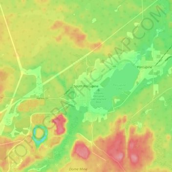
Name: South Porcupine topographic map, elevation, terrain.
Average elevation: 300 m
Minimum elevation: 251 m
Maximum elevation: 350 m
Other topographic maps
Click on a map to view its topography, its elevation and its terrain.
Kettle Lake
Canada > Ontario > Cochrane District > Timmins
Kettle Lake, Timmins, Cochrane District, Northeastern Ontario, Ontario, Canada
Average elevation: 297 m
Noted Lake
Canada > Ontario > Cochrane District > Timmins
Noted Lake, Timmins, Cochrane District, Northeastern Ontario, Ontario, Canada
Average elevation: 290 m
Dugwal
Canada > Ontario > Cochrane District > Timmins
Dugwal, Timmins, Cochrane District, Northeastern Ontario, Ontario, Canada
Average elevation: 290 m
Heart Lake
Canada > Ontario > Cochrane District > Timmins
Heart Lake, Timmins, Cochrane District, Northeastern Ontario, Ontario, Canada
Average elevation: 294 m