
Thank you for supporting this site ❤️
Make a donation
Make a donation
Kabinakagami River topographic map
Click on the map to display elevation.
Thank you for supporting this site ❤️
Make a donation
Make a donation
About this map
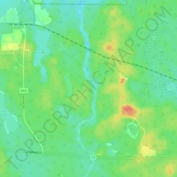
Name: Kabinakagami River topographic map, elevation, terrain.
Average elevation: 250 m
Minimum elevation: 235 m
Maximum elevation: 280 m
Thank you for supporting this site ❤️
Make a donation
Make a donation
Other topographic maps
Click on a map to view its topography, its elevation and its terrain.
Ghost Lake;Pearce Creek
Canada > Ontario > Cochrane District > Unorganized North Cochrane
Average elevation: 213 m
Thank you for supporting this site ❤️
Make a donation
Make a donation