
Thank you for supporting this site ❤️
Make a donation
Make a donation
Chatham Islands topographic map
Click on the map to display elevation.
Thank you for supporting this site ❤️
Make a donation
Make a donation
About this map
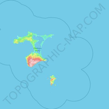
Name: Chatham Islands topographic map, elevation, terrain.
Location: Chatham Islands, New Zealand (-44.63499 -177.24469 -43.31080 -175.54142)
Average elevation: 3 m
Minimum elevation: 0 m
Maximum elevation: 291 m
Thank you for supporting this site ❤️
Make a donation
Make a donation
Other topographic maps
Click on a map to view its topography, its elevation and its terrain.
Thank you for supporting this site ❤️
Make a donation
Make a donation
Christmas Village
New Zealand > Southland > Southland District > Stewart Island / Rakiura Community
Average elevation: 85 m
Murray Beach
New Zealand > Southland > Southland District > Stewart Island / Rakiura Community
Average elevation: 48 m
Thank you for supporting this site ❤️
Make a donation
Make a donation
Merrivale
New Zealand > Southland > Southland District > Tuatapere Te Waewae Community
Average elevation: 192 m
Thank you for supporting this site ❤️
Make a donation
Make a donation
Castle Hill
New Zealand > Southland > Southland District > Northern Community
Average elevation: 569 m
Thank you for supporting this site ❤️
Make a donation
Make a donation