
Thank you for supporting this site ❤️
Make a donation
Make a donation
Murray Beach topographic map
Click on the map to display elevation.
Thank you for supporting this site ❤️
Make a donation
Make a donation
About this map
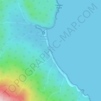
Name: Murray Beach topographic map, elevation, terrain.
Average elevation: 48 m
Minimum elevation: -2 m
Maximum elevation: 380 m
Thank you for supporting this site ❤️
Make a donation
Make a donation
Other topographic maps
Click on a map to view its topography, its elevation and its terrain.
Christmas Village
New Zealand > Southland > Southland District > Stewart Island / Rakiura Community
Average elevation: 85 m