
Thank you for supporting this site ❤️
Make a donation
Make a donation
Ngunguru topographic map
Click on the map to display elevation.
Thank you for supporting this site ❤️
Make a donation
Make a donation
About this map
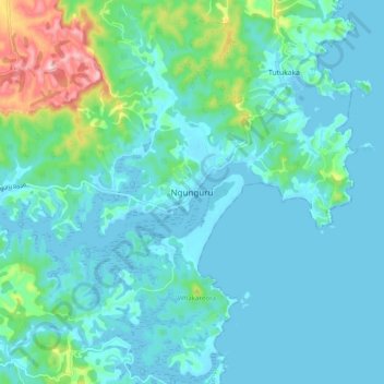
Name: Ngunguru topographic map, elevation, terrain.
Location: Ngunguru, Whangarei District, Northland, New Zealand (-35.67336 174.46078 -35.59336 174.54078)
Average elevation: 34 m
Minimum elevation: -2 m
Maximum elevation: 209 m
Thank you for supporting this site ❤️
Make a donation
Make a donation