
Zentral-Distrikt topographic map
Interactive map
Click on the map to display elevation.
About this map
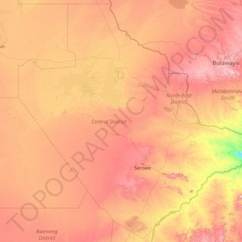
Name: Zentral-Distrikt topographic map, elevation, terrain.
Location: Zentral-Distrikt, Botsuana (-23.96232 23.88413 -19.00003 29.37389)
Average elevation: 1,006 m
Minimum elevation: 576 m
Maximum elevation: 1,782 m
Other topographic maps
Click on a map to view its topography, its elevation and its terrain.
Selebi Phikwe
Botsuana > Zentral-Distrikt > Selebi Phikwe
Selebi Phikwe, Zentral-Distrikt, Botsuana
Average elevation: 863 m
Ghanzi
Botsuana > Ghanzi District > Ghanzi
Ghanzi, Ghanzi District, Botsuana
Average elevation: 1,143 m
Mopipi
Botsuana > Zentral-Distrikt > Mopipi
Mopipi, Zentral-Distrikt, Botsuana
Average elevation: 908 m
Chobe National Park
Chobe National Park, Nogatsaa - Savuti, Chobe District, Botsuana
Average elevation: 964 m