
Thank you for supporting this site ❤️
Make a donation
Make a donation
Eatonville topographic map
Click on the map to display elevation.
Thank you for supporting this site ❤️
Make a donation
Make a donation
About this map
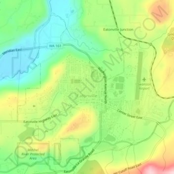
Name: Eatonville topographic map, elevation, terrain.
Location: Eatonville, Pierce County, Washington, United States (46.85716 -122.28731 46.88223 -122.24436)
Average elevation: 244 m
Minimum elevation: 146 m
Maximum elevation: 387 m
Thank you for supporting this site ❤️
Make a donation
Make a donation
Other topographic maps
Click on a map to view its topography, its elevation and its terrain.
University Place
United States > Washington > Pierce County > Tacoma > University Place
Average elevation: 58 m