
Thank you for supporting this site ❤️
Make a donation
Make a donation
The Barrier topographic map
Click on the map to display elevation.
Thank you for supporting this site ❤️
Make a donation
Make a donation
About this map
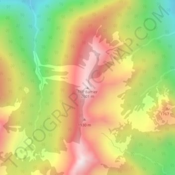
Name: The Barrier topographic map, elevation, terrain.
Location: The Barrier, Pierce County, Washington, United States (46.87629 -121.57218 46.87639 -121.57208)
Average elevation: 1,623 m
Minimum elevation: 1,202 m
Maximum elevation: 2,004 m
Thank you for supporting this site ❤️
Make a donation
Make a donation
Other topographic maps
Click on a map to view its topography, its elevation and its terrain.