
Cobb County topographic map
Interactive map
Click on the map to display elevation.
About this map
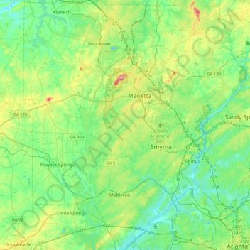
Name: Cobb County topographic map, elevation, terrain.
Location: Cobb County, Georgia, United States (33.74351 -84.73964 34.08178 -84.37473)
Average elevation: 301 m
Minimum elevation: 223 m
Maximum elevation: 529 m
Other topographic maps
Click on a map to view its topography, its elevation and its terrain.
Bethlehem
United States > Georgia > Barrow County
Bethlehem, Barrow County, Georgia, United States
Average elevation: 258 m
Sandy Springs
United States > Georgia > Fulton County
Sandy Springs, Fulton County, Georgia, United States
Average elevation: 301 m
Columbus
United States > Georgia > Muscogee County
Columbus, Muscogee County, Georgia, United States
Average elevation: 130 m
Sugar Hill
United States > Georgia > Gwinnett County
Sugar Hill, Gwinnett County, Georgia, United States
Average elevation: 332 m
Bacon County
Bacon County, Georgia, 31510, United States
Average elevation: 55 m
Winston
United States > Georgia > Douglas County
Winston, Douglas County, Georgia, 30187, United States
Average elevation: 340 m
Athens-Clarke County Unified Government
United States > Georgia > Athens-Clarke County
Athens-Clarke County Unified Government, Athens-Clarke County, Georgia, United States
Average elevation: 219 m
Savannah
United States > Georgia > Chatham County
Savannah, Chatham County, Georgia, United States
Average elevation: 4 m
Augusta
United States > Georgia > Richmond County
Augusta, Richmond County, Georgia, United States
Average elevation: 89 m
Clarksboro
United States > Georgia > Jackson County
Clarksboro, Jackson County, Georgia, United States
Average elevation: 245 m
Marietta
United States > Georgia > Cobb County
Marietta, Cobb County, Georgia, United States
Average elevation: 323 m
Nebo
United States > Georgia > Paulding County > Hiram
Nebo, Hiram, Paulding County, Georgia, 30140, United States
Average elevation: 317 m
Hagan
United States > Georgia > Evans County
Hagan, Evans County, Georgia, 30417, United States
Average elevation: 53 m
Atlanta
United States > Georgia > Fulton County
Atlanta, Fulton County, Georgia, 30303, United States
Average elevation: 285 m
North Decatur
United States > Georgia > DeKalb County
North Decatur, DeKalb County, Georgia, 30322, United States
Average elevation: 296 m
Gwinnett County
Gwinnett County, Georgia, United States
Average elevation: 302 m
Macon
United States > Georgia > Bibb County
Macon, Bibb County, Georgia, United States
Average elevation: 127 m
Athens
United States > Georgia > Athens
Athens, Athens-Clarke County, Georgia, 303341458, United States
Average elevation: 221 m