
Thank you for supporting this site ❤️
Make a donation
Make a donation
Clarksboro topographic map
Click on the map to display elevation.
Thank you for supporting this site ❤️
Make a donation
Make a donation
About this map
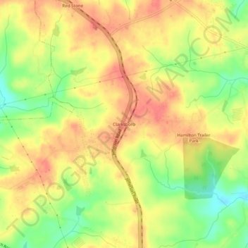
Name: Clarksboro topographic map, elevation, terrain.
Location: Clarksboro, Jackson County, Georgia, United States (34.02122 -83.51822 34.06122 -83.47822)
Average elevation: 245 m
Minimum elevation: 211 m
Maximum elevation: 267 m
Thank you for supporting this site ❤️
Make a donation
Make a donation