
Thank you for supporting this site ❤️
Make a donation
Make a donation
Satilla River topographic map
Click on the map to display elevation.
Thank you for supporting this site ❤️
Make a donation
Make a donation
About this map
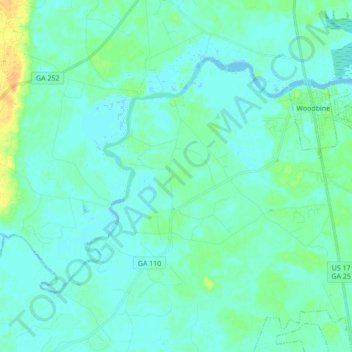
Name: Satilla River topographic map, elevation, terrain.
Location: Satilla River, Camden County, Georgia, 31568, United States (30.88655 -81.85501 30.99628 -81.40125)
Average elevation: 4 m
Minimum elevation: -3 m
Maximum elevation: 25 m
Thank you for supporting this site ❤️
Make a donation
Make a donation
Other topographic maps
Click on a map to view its topography, its elevation and its terrain.
Thank you for supporting this site ❤️
Make a donation
Make a donation
Crooked River Plantation
United States > Georgia > Camden County > St. Marys > Crooked River Plantation
Average elevation: 5 m