
Make a donation
Marsabit County topographic map
Click on the map to display elevation.
Make a donation
Marsabit County
The county is located in central north Kenya. It borders the eastern shore of Lake Turkana. Important topographical features are: Ol Donyo Ranges 2,066 m [6,778 ft] in the southwest, Mount Marsabit 1,865 m [6,119 ft] in the central part of the county, Hurri Hills 1,685 m [5,528 ft] in the northeastern part of the county, Mount Kulal 2,235 m [7,333 ft] in the northwest and the mountains around Sololo-Moyale escarpment up to 1,400 m [4,600 ft] in the northeast. The Chalbi Desert makes up much of the center region of the county.
Make a donation
About this map
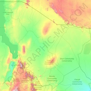
Name: Marsabit County topographic map, elevation, terrain.
Location: Marsabit County, Eastern, Kenya (1.26103 36.04932 4.45507 39.34650)
Average elevation: 699 m
Minimum elevation: 218 m
Maximum elevation: 2,806 m
Make a donation
Other topographic maps
Click on a map to view its topography, its elevation and its terrain.
Make a donation
Mombasa
Being a coastal town, Mombasa is characterised by a flat topography. The town of Mombasa is centred on Mombasa Island, but extends to the mainland. The island is separated from the mainland by two creeks, Port Reitz in the south and Tudor Creek in the north.
Average elevation: 32 m
Make a donation