
Thank you for supporting this site ❤️
Make a donation
Make a donation
Oyugis topographic map
Click on the map to display elevation.
Thank you for supporting this site ❤️
Make a donation
Make a donation
About this map
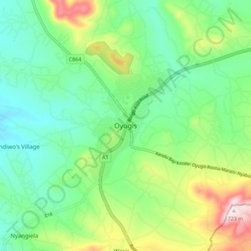
Name: Oyugis topographic map, elevation, terrain.
Location: Oyugis, Homa Bay, Nyanza, 40222, Kenya (-0.54991 34.69458 -0.46991 34.77458)
Average elevation: 1,432 m
Minimum elevation: 1,300 m
Maximum elevation: 1,728 m
Thank you for supporting this site ❤️
Make a donation
Make a donation