
Priekules novads topographic map
Interactive map
Click on the map to display elevation.
About this map
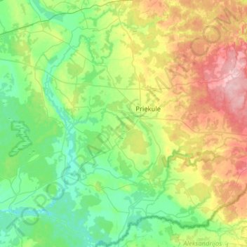
Name: Priekules novads topographic map, elevation, terrain.
Location: Priekules novads, Koerland, LV-3434, Letland (56.28885 21.35200 56.57505 21.76955)
Average elevation: 60 m
Minimum elevation: 7 m
Maximum elevation: 189 m
Other topographic maps
Click on a map to view its topography, its elevation and its terrain.
Bigauņciems
Letland > Koerland > Tukuma novads > Lapmežciema pagasts
Bigauņciems, Lapmežciema pagasts, Tukuma novads, Koerland, Letland
Average elevation: 2 m
Priekule
Letland > Koerland > Dienvidkurzemes novads
Priekule, Dienvidkurzemes novads, Koerland, Letland
Average elevation: 70 m