
Dundagas novads topographic map
Interactive map
Click on the map to display elevation.
About this map
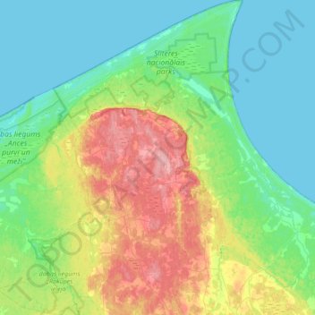
Name: Dundagas novads topographic map, elevation, terrain.
Location: Dundagas novads, Letland (57.39463 22.07709 57.75912 22.61573)
Average elevation: 27 m
Minimum elevation: 0 m
Maximum elevation: 99 m
Other topographic maps
Click on a map to view its topography, its elevation and its terrain.
Bigauņciems
Letland > Koerland > Tukuma novads > Lapmežciema pagasts
Bigauņciems, Lapmežciema pagasts, Tukuma novads, Koerland, Letland
Average elevation: 2 m
Priekule
Letland > Koerland > Dienvidkurzemes novads
Priekule, Dienvidkurzemes novads, Koerland, Letland
Average elevation: 70 m
Priekules novads
Priekules novads, Koerland, LV-3434, Letland
Average elevation: 60 m