
Ashanti Region topographic map
Interactive map
Click on the map to display elevation.
About this map
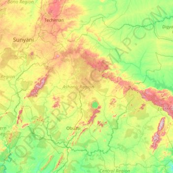
Name: Ashanti Region topographic map, elevation, terrain.
Location: Ashanti Region, Ghana (5.85482 -2.45159 7.62270 -0.23761)
Average elevation: 208 m
Minimum elevation: 33 m
Maximum elevation: 819 m
Other topographic maps
Click on a map to view its topography, its elevation and its terrain.
Tolon
Ghana > Northern Region > Tolon District
Tolon, Tolon District, Northern Region, Ghana
Average elevation: 161 m
East Mamprusi Municipal District
East Mamprusi Municipal District, North East Region, Ghana
Average elevation: 211 m
Atua
Ghana > Western North Region > Aowin Municipal District > Enchi
Atua, Zongo, Enchi, Aowin Municipal District, Western North Region, Ghana
Average elevation: 89 m
Atua
Ghana > Western North Region > Aowin Municipal District > Enchi
Atua, Zongo, Enchi, Aowin Municipal District, Western North Region, Ghana
Average elevation: 88 m
Kassena Nankana West District
Kassena Nankana West District, Upper East Region, Ghana
Average elevation: 233 m