
Thank you for supporting this site ❤️
Make a donation
Make a donation
Upper East Region topographic map
Click on the map to display elevation.
Thank you for supporting this site ❤️
Make a donation
Make a donation
About this map
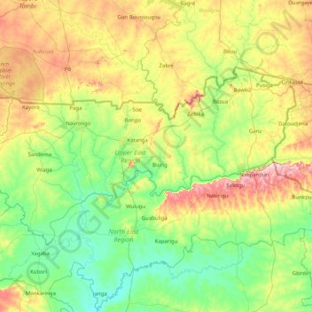
Name: Upper East Region topographic map, elevation, terrain.
Location: Upper East Region, Ghana (10.27442 -1.57305 11.17486 0.03442)
Average elevation: 214 m
Minimum elevation: 110 m
Maximum elevation: 522 m
Thank you for supporting this site ❤️
Make a donation
Make a donation
Other topographic maps
Click on a map to view its topography, its elevation and its terrain.
Juba Villas
Ghana > Greater Accra Region > La-Dade-Kotopon Municipal District > Accra
Average elevation: 42 m
Thank you for supporting this site ❤️
Make a donation
Make a donation