
Sornard topographic map
Interactive map
Click on the map to display elevation.
About this map
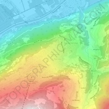
Name: Sornard topographic map, elevation, terrain.
Location: Sornard, Nendaz, Conthey, Valais, 1997, Suisse (46.16832 7.28332 46.20832 7.32332)
Average elevation: 1,026 m
Minimum elevation: 473 m
Maximum elevation: 1,888 m
Other topographic maps
Click on a map to view its topography, its elevation and its terrain.
Châteauneuf
Suisse > Valais > Conthey > Conthey
Châteauneuf, Conthey, Valais, 1964, Suisse
Average elevation: 541 m
Brignon
Suisse > Valais > Conthey > Basse-Nendaz
Brignon, Basse-Nendaz, Nendaz, Conthey, Valais, 1997, Suisse
Average elevation: 1,105 m
Haute Nendaz
Haute Nendaz, Nendaz, Conthey, Valais, 1997, Suisse
Average elevation: 1,144 m
Plan-Conthey
Suisse > Valais > Conthey > Conthey
Plan-Conthey, Conthey, Valais, 1964, Suisse
Average elevation: 600 m
Barrage de Cleuson
Suisse > Valais > Conthey > Nendaz
Barrage de Cleuson, Nendaz, Conthey, Valais, 1997, Suisse
Average elevation: 2,282 m