
Make a donation
Dahlem topographic map
Click on the map to display elevation.
Make a donation
About this map
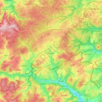
Name: Dahlem topographic map, elevation, terrain.
Location: Dahlem, Kreis Euskirchen, Noordrijn-Westfalen, 53949, Duitsland (50.33548 6.41299 50.44345 6.60707)
Average elevation: 541 m
Minimum elevation: 418 m
Maximum elevation: 665 m
Make a donation
Other topographic maps
Click on a map to view its topography, its elevation and its terrain.
Blankenheim
Duitsland > Noordrijn-Westfalen > Kreis Euskirchen > Blankenheim > Blankenheim
Average elevation: 517 m
Hellenthal
Duitsland > Noordrijn-Westfalen > Kreis Euskirchen > Hellenthal > Hellenthal
Average elevation: 514 m
Make a donation
Witscheiderhof
Duitsland > Noordrijn-Westfalen > Kreis Euskirchen > Bad Münstereifel
Average elevation: 422 m
Make a donation
Mutscheid
Duitsland > Noordrijn-Westfalen > Kreis Euskirchen > Bad Münstereifel
Average elevation: 416 m
Steinfelderheistert
Duitsland > Noordrijn-Westfalen > Kreis Euskirchen > Kall > Wahlen
Average elevation: 518 m
Make a donation
Mutscheid
Duitsland > Noordrijn-Westfalen > Kreis Euskirchen > Bad Münstereifel
Average elevation: 416 m
Make a donation
Make a donation
Make a donation