
Thank you for supporting this site ❤️
Make a donation
Make a donation
Sieberath topographic map
Click on the map to display elevation.
Thank you for supporting this site ❤️
Make a donation
Make a donation
About this map
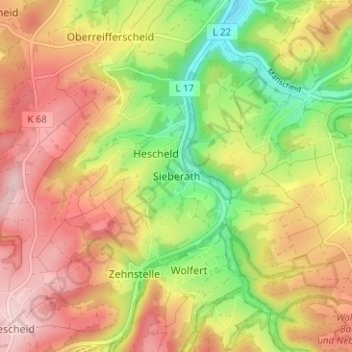
Name: Sieberath topographic map, elevation, terrain.
Average elevation: 538 m
Minimum elevation: 425 m
Maximum elevation: 636 m
Thank you for supporting this site ❤️
Make a donation
Make a donation
Other topographic maps
Click on a map to view its topography, its elevation and its terrain.
Thank you for supporting this site ❤️
Make a donation
Make a donation
Thank you for supporting this site ❤️
Make a donation
Make a donation
Eifelpark Kronenburger See
Duitsland > Noordrijn-Westfalen > Kreis Euskirchen > Kronenburg
Average elevation: 554 m
Thank you for supporting this site ❤️
Make a donation
Make a donation
Kronenburger See
Duitsland > Noordrijn-Westfalen > Kreis Euskirchen > Kronenburg
Average elevation: 554 m