
Make a donation
Carbon County topographic map
Click on the map to display elevation.
Make a donation
About this map
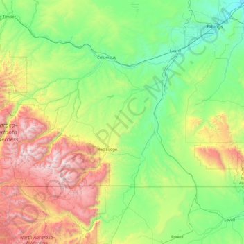
Name: Carbon County topographic map, elevation, terrain.
Location: Carbon County, Montana, United States (44.99944 -109.79869 45.63864 -108.09807)
Average elevation: 1,639 m
Minimum elevation: 916 m
Maximum elevation: 3,850 m
Make a donation
Other topographic maps
Click on a map to view its topography, its elevation and its terrain.
Make a donation
Bancroft Pond Nature Area
United States > Montana > Missoula County > Missoula
Average elevation: 1,005 m
Make a donation
Make a donation
Make a donation
Bozeman
United States > Montana > Gallatin County > Bozeman
Bozeman is located at an elevation of 4,820 feet (1,470 m). The Bridger Mountains are to the north-northeast, the Tobacco Root Mountains to the west-south-west, the Big Belt Mountains and Horseshoe Hills to the northwest, the Hyalite Peaks of the northern Gallatin Range to the south and the Spanish Peaks of…
Average elevation: 1,679 m
Make a donation
Make a donation
Make a donation