
Devon Island topographic map
Click on the map to display elevation.
Devon Island
Because of its relatively high elevation and its extreme northern latitude, it supports only a meagre population of muskox and small birds and mammals; the island does support hypolith communities. Animal life is concentrated in the Truelove Lowland area of the island, which has a favourable microclimate and supports relatively lush Arctic vegetation. Temperatures during the brief (40 to 55 days) growing season seldom exceed 10 °C (50 °F), and in winter can plunge to as low as −50 °C (−58 °F). With a polar desert ecology, Devon Island receives very little precipitation.
About this map
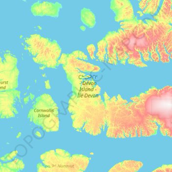
Name: Devon Island topographic map, elevation, terrain.
Location: Devon Island, Canada (74.45740 -96.97025 77.07025 -79.44148)
Average elevation: 156 m
Minimum elevation: -1 m
Maximum elevation: 1,920 m
Other topographic maps
Click on a map to view its topography, its elevation and its terrain.
Laurentian Mountains
One of Quebec's official regions is called Laurentides. The mountain range runs through four other regions; Capitale-Nationale, Outaouais, Lanaudière, and Mauricie. The elevation generally ranges from around 500 m (1,640 ft) to 1,000 m (3,280 ft) with Mont Raoul-Blanchard being its highest peak, at 1,166 m…
Average elevation: 348 m
Christian Island
Canada > Ontario > Simcoe County
Christian Island is a large island in Georgian Bay close to the communities of Penetanguishene and Midland, Ontario. The island, with its neighbours Hope Island and Beckwith Island, is a 5,428.1 hectares (13,413.1 acres) Ojibwa reserve, known as Christian Island Indian Reserve No. 30. Together with the 7.5…
Average elevation: 185 m
Toronto
Despite its deep ravines, Toronto is not remarkably hilly, but its elevation does increase steadily away from the lake. Elevation differences range from 76.5 metres (251 ft) above sea level at the Lake Ontario shore to 209 m (686 ft) ASL near the York University grounds in the city's north end at the…
Average elevation: 113 m
Abbotsford
Canada > British Columbia > Fraser Valley Regional District > Abbotsford
Average elevation: 115 m
Banff
Canada > Alberta > Banff > Banff
Banff is a town within Banff National Park in Alberta, Canada. It is located in Alberta's Rockies along the Trans-Canada Highway, approximately 126 km (78 mi) west of Calgary and 58 km (36 mi) east of Lake Louise. At 1,400 to 1,630 m (4,590 to 5,350 ft) above sea level, Banff is the community with the second…
Average elevation: 1,615 m
Sharbot Lake
Canada > Ontario > Frontenac County > Central Frontenac > Sharbot Lake
Average elevation: 201 m
Moraine Lake
Canada > Alberta > Division No. 15
Moraine Lake is a glacially fed lake in Banff National Park, 14 kilometres (8.7 mi) outside the hamlet of Lake Louise, Alberta, Canada. It is situated in the Valley of the Ten Peaks, at an elevation of approximately 1,884 metres (6,181 ft). The lake has a surface area of 50 hectares (120 acres).
Average elevation: 2,101 m
Richmond
Canada > British Columbia > Metro Vancouver Regional District > Richmond
Average elevation: 15 m
Burnaby
Canada > British Columbia > Metro Vancouver Regional District > Burnaby
Burnaby occupies 98.6 square kilometres (38.1 sq mi) and is located at the geographic centre of the Metro Vancouver area and home to the Metro Vancouver regional government in Metrotown. Situated between the city of Vancouver on the west and Port Moody, Coquitlam, and New Westminster on the east, Burnaby is…
Average elevation: 144 m
Qualicum Beach
Canada > British Columbia > Regional District of Nanaimo > Qualicum Beach > Qualicum Beach
Average elevation: 47 m
Beausoleil Island
Canada > Ontario > Muskoka District > Georgian Bay Township
Average elevation: 180 m
Capilano Lake
Canada > British Columbia > Metro Vancouver Regional District > West Vancouver
Average elevation: 353 m
Whitehorse
Whitehorse has a subarctic climate (Köppen climate classification: Dfc) and lies in the rain shadow of the Coast Mountains, causing precipitation totals to be quite low year-round. Due to the city's location in the Whitehorse valley, the climate is milder than other comparable northern communities such as…
Average elevation: 1,008 m
Whistler
Canada > British Columbia > Squamish-Lillooet Regional District > Whistler Resort Municipality > Whistler
Average elevation: 996 m
Fogo Island
Canada > Newfoundland and Labrador > Joe Batt's Arm-Barr'd Islands-Shoal Bay
Average elevation: 3 m
Ryder Lake
Canada > British Columbia > Fraser Valley Regional District > Chilliwack
Average elevation: 255 m
Nemaiah Valley
Canada > British Columbia > Cariboo Regional District > Area J (West Chilcotin)
Average elevation: 1,270 m
Souris
Canada > Manitoba > Division No. 7 > Municipality of Souris – Glenwood
Average elevation: 433 m
Duffey Lake
Canada > British Columbia > Squamish-Lillooet Regional District > Area B (Cayoosh/Pavilion)
Average elevation: 1,539 m
Slate Islands
Canada > Ontario > Kenora District > Unorganized Kenora District
Average elevation: 322 m
Stump Lake
Canada > British Columbia > Regional District of Kootenay Boundary > Area E (Beaverdell/West Boundary)
Average elevation: 1,321 m
Windermere Lake
Canada > Ontario > Kenora District > Unorganized Kenora District
Average elevation: 422 m
Kashabowie
Canada > Ontario > Thunder Bay District > Unorganized Thunder Bay District
Average elevation: 467 m
Moose Creek
Canada > Ontario > Stormont, Dundas and Glengarry Counties > North Stormont
Average elevation: 87 m
Powder King Peak
Canada > British Columbia > Regional District of Fraser-Fort George > Area G (Crooked River/Parsnip)
Average elevation: 1,381 m
Mary's Peak
Canada > British Columbia > Capital Regional District > Juan de Fuca Electoral Area
Average elevation: 458 m
Mount Burwell
Canada > British Columbia > Metro Vancouver Regional District > Electoral Area A
Average elevation: 1,100 m
Durieu
Canada > British Columbia > Fraser Valley Regional District > Area F (McConnell Creek/Hatzic Prairie)
Average elevation: 142 m
Arctic Bay
Canada > Nunavut > Qikiqtaaluk Region
Arctic Bay experiences a tundra climate (Köppen: ET) like most northern Canadian territories at low elevations, with long, very cold winters and short, cool to cold summers. July is the only month with an average low temperature above freezing. Its climate does not differ from the more severe subarctic…
Average elevation: 160 m
Sinclair Mills
Canada > British Columbia > Regional District of Fraser-Fort George > Area F (Willow River/Upper Fraser)
Average elevation: 659 m
Port Mouton Island
Canada > Nova Scotia > Queens County > South West Port Mouton
Average elevation: 27 m
White Man Pass
Canada > British Columbia > Regional District of East Kootenay > Area F (Columbia Lake/Windermere Lake)
Average elevation: 2,199 m
Ara Lake
Canada > Ontario > Thunder Bay District > Unorganized Thunder Bay District
Average elevation: 308 m
St. Malo
Canada > Manitoba > Division No. 2 > Rural Municipality of De Salaberry
Average elevation: 253 m