
Thank you for supporting this site ❤️
Make a donation
Make a donation
Mount Burwell topographic map
Click on the map to display elevation.
Thank you for supporting this site ❤️
Make a donation
Make a donation
About this map
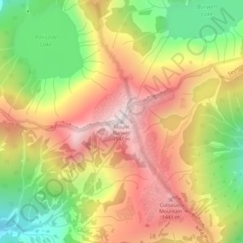
Name: Mount Burwell topographic map, elevation, terrain.
Average elevation: 1,100 m
Minimum elevation: 633 m
Maximum elevation: 1,528 m
Thank you for supporting this site ❤️
Make a donation
Make a donation
Other topographic maps
Click on a map to view its topography, its elevation and its terrain.
University of British Columbia
Canada > British Columbia > Metro Vancouver Regional District > Electoral Area A
Average elevation: 58 m
Bowyer Island
Canada > British Columbia > Metro Vancouver Regional District > Electoral Area A
Average elevation: 10 m