
Chattogram Division topographic map
Interactive map
Click on the map to display elevation.
About this map
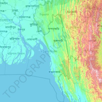
Name: Chattogram Division topographic map, elevation, terrain.
Location: Chattogram Division, Bangladesh (20.36791 90.53934 24.27645 92.68030)
Average elevation: 297 m
Minimum elevation: -2 m
Maximum elevation: 2,985 m
Other topographic maps
Click on a map to view its topography, its elevation and its terrain.
Flood
Bangladesh > Barishal Division > Borhanuddin Subdistrict
Flood, Borhanuddin Subdistrict, Bhola District, Barishal Division, Bangladesh
Average elevation: 1 m
Khuruskul
Bangladesh > Chattogram Division > Khuruskul
Khuruskul, Cox's Bazar District, Chattogram Division, ৪৭০০, Bangladesh
Average elevation: 5 m
Alampur
Bangladesh > Khulna Division > Alampur
Alampur, Kushtia District, Khulna Division, Bangladesh
Average elevation: 13 m
Brahmaputra River
Bangladesh > Mymensingh Division > Mymensingh
Brahmaputra River, Mymensingh, Mymensingh District, Mymensingh Division, 2230, Bangladesh
Average elevation: 12 m
Rangamati Hill District
Bangladesh > Chattogram Division
Rangamati Hill District, Chattogram Division, 4500, Bangladesh
Average elevation: 276 m