
Jasaan topographic map
Click on the map to display elevation.
About this map
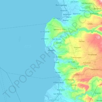
Name: Jasaan topographic map, elevation, terrain.
Location: Jasaan, Misamis Oriental, Northern Mindanao, 9003, Philippines (8.59150 124.60242 8.70460 124.81394)
Average elevation: 125 m
Minimum elevation: -4 m
Maximum elevation: 820 m
Other topographic maps
Click on a map to view its topography, its elevation and its terrain.
Claveria
Philippines > Misamis Oriental
The town has a generally rugged topography, characterized by gently rolling hills and mountains with cliffs and escarpments. The soil is classified as Jasaan clay, with a deep soil profile (greater than 1 m) and rapid drainage. It is generally acidic (pH 3.9 to 5.2), with low cation exchange capacity (CEC),…
Average elevation: 663 m
Mount Balatukan
Philippines > Misamis Oriental
Mount Balatukan is a stratovolcano with a listed elevation of 2,450 meters (8,040 ft) asl (GVP). The Philippine Institute of Volcanology and Seismology (PHIVOLCS).
Average elevation: 1,926 m
Gitagum
Philippines > Misamis Oriental
Gitagum is shaped like a native fan. Its broad limestone plain within 0 – 100 meters elevation stretches from Iligan Bay towards the easier part, narrowing down to rise 100–300 meters above the sea level forming low and high relief shale/sandstone hills. Ultra basic high relief hills at the southwestern…
Average elevation: 46 m
Cagayan de Oro River
Philippines > Misamis Oriental > Cagayan De Oro > Balulang
Average elevation: 98 m