
Thank you for supporting this site ❤️
Make a donation
Make a donation
Initao topographic map
Click on the map to display elevation.
Thank you for supporting this site ❤️
Make a donation
Make a donation
About this map
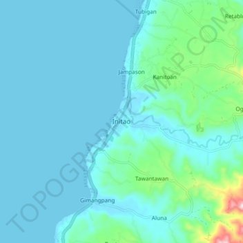
Name: Initao topographic map, elevation, terrain.
Location: Initao, Misamis Oriental, Northern Mindanao, 9022, Philippines (8.45754 124.26561 8.53754 124.34561)
Average elevation: 42 m
Minimum elevation: -1 m
Maximum elevation: 341 m
Thank you for supporting this site ❤️
Make a donation
Make a donation
Other topographic maps
Click on a map to view its topography, its elevation and its terrain.
Thank you for supporting this site ❤️
Make a donation
Make a donation
Cagayan de Oro River
Philippines > Misamis Oriental > Cagayan De Oro > Balulang
Average elevation: 98 m
Thank you for supporting this site ❤️
Make a donation
Make a donation
Thank you for supporting this site ❤️
Make a donation
Make a donation
Thank you for supporting this site ❤️
Make a donation
Make a donation