
Angeles topographic map
Click on the map to display elevation.
Angeles
Sapangbato is the largest barangay in Angeles in terms of territory, with a total land area of 104,694 sq. meters and a population of 11,262. Located northwest of Angeles near Clark Freeport Zone, it is identified as the barangay in Angeles with the highest elevation of 750 feet above sea level. It is home to Fort Stotsenburg, also known as the Parade Grounds of Clark. apl.de.ap, member of the hip hop group the Black Eyed Peas, hails from Sapangbato. The famous Puning Hot Springs of Barangay Inararo in Porac are accessed through Sitio Target in Sapangbato.
About this map
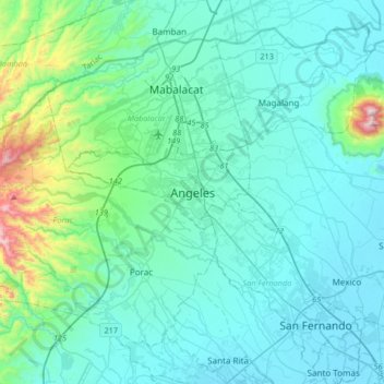
Name: Angeles topographic map, elevation, terrain.
Location: Angeles, Pampanga, Central Luzon, 2009, Philippines (14.97894 120.42753 15.29894 120.74753)
Average elevation: 128 m
Minimum elevation: -1 m
Maximum elevation: 989 m
Other topographic maps
Click on a map to view its topography, its elevation and its terrain.
Guagua
The climate and topographical features of the vast land of Guagua make it ideal for the growing of fruit trees and vegetables. Among the fruit trees most fitting to be planted are mangoes, guavas, santol, star apples, and bananas. For vegetables, sitao, upo, ampalaya, gabi and cucumber are the most commonly…
Average elevation: 9 m
Floridablanca
Floridablanca is located on the western part of Pampanga along the Zambales mountain ranges and is bounded by the municipalities of Porac on the north, Lubao on the south, Guagua on the east, and Dinalupihan, Bataan on the west. It is 40 kilometers (25 mi) from the city of San Fernando and 106 kilometers (66…
Average elevation: 35 m
Floridablanca
The town is at an elevation of 12 feet (3.7 m) above sea level. Floridablanca is north of Dinalupihan via Dinalupihan-Floridablanca Access Road at the Bataan-Pampanga boundary line.
Average elevation: 35 m
Floridablanca
The town is at an elevation of 12 feet (3.7 m) above sea level. Floridablanca is north of Dinalupihan via Dinalupihan-Floridablanca Access Road at the Bataan-Pampanga boundary line.
Average elevation: 35 m
Floridablanca
The town is at an elevation of 12 feet (3.7 m) above sea level. Floridablanca is north of Dinalupihan via Dinalupihan-Floridablanca Access Road at the Bataan-Pampanga boundary line.
Average elevation: 35 m
Floridablanca
The town is at an elevation of 12 feet (3.7 m) above sea level. Floridablanca is north of Dinalupihan via Dinalupihan-Floridablanca Access Road at the Bataan-Pampanga boundary line.
Average elevation: 35 m