
Thank you for supporting this site ❤️
Make a donation
Make a donation
Western Highlands topographic map
Click on the map to display elevation.
Thank you for supporting this site ❤️
Make a donation
Make a donation
About this map
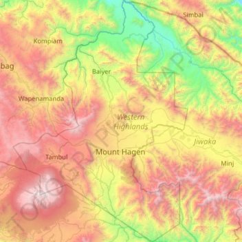
Name: Western Highlands topographic map, elevation, terrain.
Location: Western Highlands, Highlands Region, Papua New Guinea (-6.24445 143.77092 -5.21158 144.52006)
Average elevation: 1,846 m
Minimum elevation: 286 m
Maximum elevation: 4,272 m
Thank you for supporting this site ❤️
Make a donation
Make a donation
Other topographic maps
Click on a map to view its topography, its elevation and its terrain.
Thank you for supporting this site ❤️
Make a donation
Make a donation
Kainantu
Papua New Guinea > Eastern Highlands
A narrow south-east-trending dissected plateau dominates area to the south; it forms the watershed between rivers draining north to the Markham-Ramu Graben, and those draining south to the Papuan coast. The plateau ranges in elevation between 7,500 feet (2,300 m) and 8,000 feet (2,400 m) above sea level, and…
Average elevation: 1,628 m
Thank you for supporting this site ❤️
Make a donation
Make a donation
Thank you for supporting this site ❤️
Make a donation
Make a donation