
Hazaribagh topographic map
Interactive map
Click on the map to display elevation.
About this map
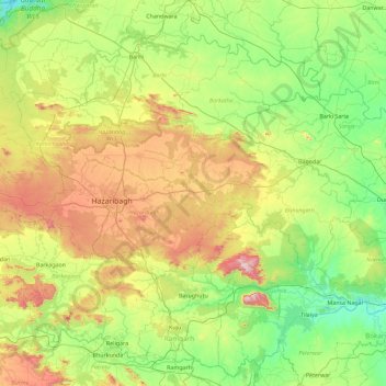
Name: Hazaribagh topographic map, elevation, terrain.
Location: Hazaribagh, Jharkhand, India (23.65129 85.01114 24.36450 85.92725)
Average elevation: 421 m
Minimum elevation: 185 m
Maximum elevation: 956 m
Other topographic maps
Click on a map to view its topography, its elevation and its terrain.
Hazaribagh
Hazaribagh, Hazaribagh District, Jharkhand, India
Average elevation: 582 m