
Make a donation
An Giang Province topographic map
Click on the map to display elevation.
Make a donation
About this map
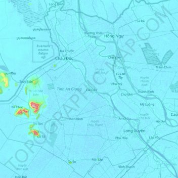
Name: An Giang Province topographic map, elevation, terrain.
Location: An Giang Province, Vietnam (8.99456 103.05224 10.96229 105.57562)
Average elevation: 16 m
Minimum elevation: -3 m
Maximum elevation: 1,062 m
Make a donation
Other topographic maps
Click on a map to view its topography, its elevation and its terrain.
Ho Chi Minh City
Ho Chi Minh City is located in the south-eastern region of Vietnam, 1,760 km (1,090 mi) south of Hanoi. The average elevation is 5 m (16 ft) above sea level for the city center and 16 m (52 ft) for the suburb areas. It borders Tây Ninh Province and Bình Dương Province to the north, Đồng Nai Province and…
Average elevation: 6 m
Make a donation
Make a donation
Sa Pa
Vietnam > Lao Cai province > Sa Pa
Sa Pa District is in Lào Cai Province, northwest Vietnam, 380 km northwest of Hanoi close to the border with China. The Hoàng Liên Son range of mountains dominates the district, which is at the eastern extremity of the Himalayas. This range includes Vietnam's highest mountain, Fan Si Pan, at a height of…
Average elevation: 1,520 m
Make a donation
Sông Lại Giang
Vietnam > Gia Lai Province > Phường Hoài Nhơn Nam > Khu phố Vĩnh Phụng 2
Average elevation: 45 m
Make a donation
Huế
Vietnam > Huế > Thuận Hóa Ward
The Perfume River (called Sông Hương or Hương Giang in Vietnamese) passes through the center of the city. The city also accommodates the Tam Giang–Cau Hai lagoon, the largest lagoon in Southeast Asia, which is 68 kilometres (42 mi) long with a surface area of 220 square kilometres (85 sq mi). The city…
Average elevation: 30 m
Make a donation
Quảng trường Thành phố Phan Rang-Tháp Chàm
Vietnam > Ninh Thuan province > Phan Rang – Tháp Chàm
Average elevation: 5 m
Make a donation
Make a donation
Make a donation
Make a donation
Make a donation
quang truong dai doan ket
Vietnam > Gia Lai Province > Phường Pleiku > Pleiku Ward
Average elevation: 755 m
Make a donation
Make a donation
Make a donation
Make a donation
Make a donation
Make a donation
Make a donation
Make a donation
Make a donation
Make a donation
Make a donation
Make a donation
Make a donation
Bản Nậm Khao
Vietnam > Lai Chau province > Mường Tè District > Nậm Khao Commune > Nậm Khao
Average elevation: 609 m
Make a donation
Hạ Long Bay
Vietnam > Quang Ninh Province > Ha Long
Due to a simultaneous combination of ideal factors such as thick, pale, grey, and strong limestone layers, which are formed by fine-grained materials; hot and moist climate and slow tectonic process as a whole; Hạ Long Bay has had a complete karst evolution for 20 million years. There are many types of karst…
Average elevation: 0 m
Make a donation